
Page
017. Divisions of the atmosphere
018. Characteristics of atmospheric gases
019. How the Sun heats the Earth
020. Differential heating of the atmosphere
2–2. The Tropopause
021. Characteristics of the tropopause
022. Locating the tropopause
2–3. Atmospheric Circulation
023. Thermal and three-cell circulation
024. Forces affecting Earth’s general circulation
025. Earth’s circulation systems
026. Tertiary circulations
2–4. Jet Stream
027. General structure of jet streams
028. Polar front jet (PFJ) stream
029. Subtropical jet (STJ) stream
030. Life cycle of a jet stream
031. Jet stream and migratory pressure system relationships
2–5. Air Masses
032. Air-mass formation
033. Air-mass structure
034. Air-mass modification
035. Geographical distribution of air masses and their effect on weather
036. Influence of the Northern Hemisphere’s oceans on air-mass weather
N unit 1, we examined atmospheric physics and how physical properties affect our weather. In this unit, we cover the atmosphere in general. The old saying that "everyone talks about the weather but nobody does anything about it" is becoming increasingly less accurate. As weather journeymen, we can appreciate the advances made in the short history of meteorology as a scientific study. However, we also know the limitations involved in understanding and eventually influencing weather phenomena. Concerning understanding, you might well remember the advice in the book of Proverbs in the Bible: "Wisdom is the principal thing; therefore get wisdom, and with all thy getting (of wisdom), get understanding." This aptly implies that our understanding of any subject depends on the amount of knowledge (or wisdom) at our command. This text material aims toward increasing your understanding of the Earth’s atmosphere.
The first section of this unit covers the atmosphere in general. We review the structure, characteristics of gases, heat balance, and differential heating of the atmosphere. Following that is a discussion of the tropopause and atmospheric circulations. Next comes thorough coverage of jet streams followed by the final section’s topic of air masses. Emphasis on the importance of finding the unique features of each of these topics occurs throughout the section.
The origin of the word atmosphere is Greek, from atmos meaning vapor and sphaira meaning sphere. Literally, it is a sphere of vapor, or a gaseous envelope, surrounding a sphere or globe. The atmosphere of the Earth is an envelope of air surrounding the Earth. Without this envelope, the life forms we consider familiar could not exist. Any planet in the universe may have an atmosphere. However, research has not yet discovered another planet with an atmosphere like that of Earth.
Today, through our increased understanding of the nature of atmospheric phenomena, we can actually alter some weather phenomena. Any ambitious weather modification program, and weather forecasting itself, depends upon our comprehension of the structure of the atmosphere and the interaction of the forces operating within it.
017. Divisions of the atmosphere
We classify our atmosphere into seven layers and zones. The names of these layers in ascending order are: troposphere, tropopause, stratosphere, stratopause, mesosphere, mesopause, and thermosphere. Figure 2–1 illustrates the relative thickness, height, and temperature of these layers.
Figure 2–1. Vertical structure of the Earth’s atmosphere.
Troposphere
The troposphere, whose thickness varies with location and season, has an average height of 38,000 feet (7 miles or 11 km). Within the troposphere, the temperature decreases with height to about –55°C or –60°C. We usually assume a standard temperature decrease in the troposphere of about 6.5°C per 1,000 meters of altitude. Because the troposphere contains the most significant vertical wind motions (unstable) and water vapor and experiences all the weather affecting the Earth’s surface, it captures most of the attention of forecasters.
Tropopause
The tropopause is a thin zone of transition between the troposphere and the stratosphere. Obviously, the tropopause height varies directly with the troposphere thickness and depends largely on geographical location, season, and other factors. For example, over the poles the average tropopause height is only 5 miles, but over the Equator it is 10 miles. Below the tropopause, the temperature normally decreases as height increases. At the tropopause the temperature remains constant with height (isothermal). The tropopause extends only a few thousand feet but acts as the upper limit for the occurrence of weather.
Stratosphere
The next layer, the stratosphere, extends from the tropopause to a height of about 154,000 feet (31 miles or 48 km). Temperature within the stratosphere remains isothermal up to 100,000 feet; there it begins to warm with altitude. Temperature reaches a maximum of 7°C (45°F) at the top of the layer.
The stratosphere contains most of the ozone of our atmosphere; it is concentrated between 65,000 and 100,000 feet. The nacreous cloud (mother-of-pearl) also occurs in the stratosphere. Scientists believe there may be an association between the ozone concentration and the nacreous cloud. Because no weather occurs in the stratosphere, flying conditions are excellent.
Stratopause
At the height where the stratospheric temperatures stop increasing, there is a thin zone called the stratopause. It represents a transition between the increasing temperatures of the stratosphere and the decreasing temperatures of the mesosphere.
Mesosphere
The mesosphere extends to a height of about 262,000 feet (50 miles). In contrast to the warm upper stratosphere, temperature decreases with altitude in this layer to a minimum near –100°C (–148°F). This rapid temperature decrease causes large convective (vertical) currents. As a result, we consider the mesosphere unstable.
A cloud that occurs in the mesosphere is called the noctilucent cloud (meaning "luminous night clouds") because it appears to glow at night. It is believed that this cloud is composed of meteoric or cosmic and volcanic dust.
Also found within the mesosphere is a concentration of electrons called the "D" layer, which occurs at or about 230,000 feet. This layer reflects radio waves, thus making long distance communications possible.
Mesopause
The last transition zone is the mesopause. This zone marks the end of the temperature decrease within the mesosphere and occurs at or about 262,000 feet. Above this zone extends the atmosphere’s final layer, the thermosphere, which lacks a distinct upper boundary.
Thermosphere
Within the thermosphere, the temperature remains isothermal to 300,000 feet and then begins to increase with altitude. This layer contains noctilucent clouds and two layers that reflect radio waves. These layers, like the "D" layer, are concentrations of electrons. They are called the "E" and "F" layers.
018. Characteristics of atmospheric gases
An average sample of pure dry air taken from the atmosphere contains (by volume) 78 percent nitrogen, 21 percent oxygen, almost 1 percent argon, and 0.03 percent carbon dioxide. Two other important gases might also be present in variable amounts: ozone (trace amounts) and water vapor (1.2 percent).
Nitrogen
This is a colorless, tasteless, odorless, gaseous element. It enters the atmosphere from volcanoes and from the decay of organic matter. Plant life removes nitrogen from the atmosphere.
Oxygen
Oxygen is also colorless, tasteless, and odorless. It is a prerequisite of most forms of animal and plant life. At altitudes above about 13 miles (20 km), the radiation from the Sun breaks the oxygen down into ozone.
Argon
Just like nitrogen and oxygen, argon is colorless and odorless. It is considered an inactive gas.
Variable gases
Carbon dioxide, ozone, and water vapor are the more variable gases that significantly affect the weather in the atmosphere.
Carbon dioxide
Carbon dioxide results from the decay of vegetation, combustion, volcanic action, and similar processes. Usually, its maximum concentration occurs around cities and industrial areas. However, the actual amount of carbon dioxide varies with the seasons. There is more combustion and, therefore, more carbon dioxide produced during winter heating.
Ozone
Ozone reaches a maximum in the stratosphere. It is important because of its ability to "absorb ultraviolet radiation." Without this protection, the Sun would burn everything on Earth.
Water vapor
The third of the variable gases, water vapor, is the most important in determining weather. We could not have the type of weather we are familiar with without water vapor. Water vapor in a parcel of air makes the air lighter than a parcel of dry air. This affects the stability of the atmosphere. The warmer the air, the more water vapor it can hold. The maximum amount of water vapor the air can hold is 4 percent by volume.
019. How the Sun heats the Earth
Like anything else in the physical world, the Earth’s heat balance is subject to physical processes. These processes have physical laws to describe the relationships involved in radiation and heat exchange. We can use these basic laws to help understand the radiative heat balance between the Earth and the atmosphere. Every phenomenon that we call weather is the result of differential absorption and reradiation of solar energy (discussed earlier) and the availability of moisture.
The Earth’s temperature is decided by the intensity of the solar radiation striking the Earth’s surface. Since the Sun is the basic source of energy for our atmosphere, we must understand how this affects our temperature.
Types of radiation
The Sun’s rays strike the Earth’s surface at different angles, which we refer to as the angle of incidence. When this angle is 90° (perpendicular to Earth’s surface), the heat received is the greatest. When the rays are not perpendicular, they must penetrate the atmosphere through a greater distance. This increases the reflection, absorption, and scattering of the rays. When the rays are not perpendicular, less heat is received. The distribution of solar radiation and terrestrial (Earth’s) radiation is an extremely important factor in understanding the weather.
The intensity and wavelength of any emission from a radiating body are dependent on the temperature of the body. The hotter the body, the more intense is the radiation and the shorter are the wavelengths emitted. Since the Sun is the hottest body of our solar system, it emits the shortest wavelengths. Since all objects within our atmosphere are cooler than the Sun, they emit long-wave radiation (discussed earlier).
The significance of the difference in radiation wavelengths lies in the different way they influence the atmosphere. Approximately 35 percent of direct solar radiation is reflected back into space from clouds, the Earth’s surface, and dust in the atmosphere. The Earth absorbs some 51 percent of the incoming solar radiation (insolation) and the atmosphere absorbs the remaining 14 percent.
The portion absorbed by the Earth and the atmosphere must be reradiated to maintain the heat balance within our atmosphere. Since the reradiating bodies are cooler than the Sun, we call their radiation long-wave radiation.
Heat balance
Since incoming radiation heats the atmosphere and the Earth through absorption, these two regions should continue to get hotter and hotter. That this does not happen is due to a complex system of reradiation from the Earth and clouds. Over a long period, the heat loss from the Earth and atmosphere is equal to the heat gain. However, temporary imbalances exist at some points on Earth.
The system is complex because the water vapor in the atmosphere can absorb long-wave (terrestrial) radiation . Thus, the water vapor absorbs and reradiates long-wave radiation to and from the Earth. Because it absorbs long-wave radiation more effectively than short waves, a greenhouse effect is created.
Although the greenhouse effect was briefly discussed earlier, we’ll examine it more in depth to understand this phenomena more clearly. The greenhouse effect is a reference to the effect of clouds and water vapor acting like the glass in a greenhouse when it traps long-wave radiation below it. Here is how it works.
During the day, the Earth absorbs the short-wave radiation that passes through the atmosphere. The heat gained by the Earth is then reradiated back toward outer space as long-wave radiation. When water vapor is present, this long-wave radiation is absorbed by the vapor and then radiated toward the Earth. This process effectively keeps the heat from escaping from that portion of the Earth. This accounts for the higher temperatures on nights when a cloud cover is present.
The water vapor affects the heat balance in one other way that has significance for the meteorologist. When clouds are present during the day, the incoming solar radiation does not reach the Earth’s surface. This is due to reflection of the radiation from the top of the cloud and to some absorption and reradiation outward. About 65 percent of the solar radiation on an overcast day is lost to the Earth through reflection, backscattering, and absorption. This keeps the temperature lower during the daytime in this portion of the Earth.
020. Differential heating of the atmosphere
Earlier, you learned that water vapor is the most important gas in weather formation. Weather also depends on another important variable¾ heat. In fact, how the Earth and its atmosphere are heated is the catalyst for weather formation.
In general, the Earth and its atmosphere maintain a constant average temperature. This is due to a balance between the amount of radiated energy received from the Sun and the amount of radiated energy the Earth loses to outer space. This balance of radiation is maintained by a complex system of reradiation of thermal energy between the Earth and water vapor in the atmosphere.
While it’s true that over long periods the Earth’s temperature is somewhat constant, temperature variations occur because of differential heating of the Earth and its atmosphere. On a global scale, differential heating results from latitudinal variation in the amount of heating of the Earth and its atmosphere. On a smaller scale, other causes of differential heating exist, such as land versus water, hills versus valleys, etc. Differential heating is the true cause of the weather you observe.
Factors that influence Earth’s heating and atmosphere
The Sun is the source of heat for the Earth. To understand how differential heating occurs, you need to be familiar with factors that influence how the Sun’s energy heats the Earth and its atmosphere. These factors include radiation processes, angle of incidence of solar radiation, absorption, scattering, and albedo.
Radiation processes
Radiation from the Sun is responsible for heating the Earth’s surface. Yet, direct solar radiation accounts for only a small part of heat the atmosphere absorbs. Most radiative heating of the atmosphere is the result of reradiated energy from the Earth’s surface. Absorption of radiated energy depends partly on the wavelength of radiated energy. The wavelength of radiated energy depends on the temperature of the emitting body¾ the hotter the body, the shorter the wavelength of emitted energy.
Solar radiation has the full spectrum of electromagnetic energy, including gamma, ultraviolet, visible, infrared, and microwave radiation. Still, as the hottest body in the solar system, the bulk of the Sun’s energy is radiated in short visible wavelengths (less than 3 microns). As a significantly cooler body, the Earth’s radiation is limited to longer infrared wavelengths between 3 and 80 microns.
We can divide the spectrum into two categories¾ short-wave solar radiation (less than 3 microns) and long-wave terrestrial radiation (3 to 80 microns). Figure 2–2 shows the electromagnetic spectrum of radiated energy.
Heating of the Earth and its atmosphere depends on the ability of the individual masses involved to absorb and emit the two types of radiation. Because the atmosphere is largely transparent to incoming short-wave radiation, a large quantity reaches the Earth’s surface where it becomes absorbed and heats the Earth’s surface. The Earth then emits long-wave radiation that is readily absorbed by atmospheric gases, such as carbon dioxide and water vapor.
The only source of short-wave radiation is the Sun. All other mass emits only long-wave radiation. Therefore, any radiation, long-wave or short-wave, absorbed by water vapor and other atmospheric components becomes reradiated as long-wave radiation.
Figure 2–2. Electromagnetic spectrum.
Angle of incidence
Because of curvature of the Earth’s surface, solar radiation strikes at different angles, called angles of incidence. An angle of incidence is measured from a line perpendicular to the Earth’s surface. When solar radiation strikes perpendicular to the Earth’s surface, the angle of incidence is 0°. If it strikes at angles other than perpendicular, the angle of incidence increases as seen in figure 2–3.
Figure 2–3. Different angles of incidence.
The smaller the angle of incidence, the more the Earth’s surface is heated. The concentration of solar energy is greatest at lower angles of incidence. Notice in figure 2–4 that when the angle of incidence increases, radiation spreads over a larger area. Because the same amount of energy affects a larger area, the Earth’s surface is heated less. This effect becomes magnified over the Earth’s curved surface. There are two separate motions of the Earth that affect angle of incidence¾ rotation and revolution.
Earth’s rotation
The Earth spins about its axis once each 24 hours. Its rotation is responsible for daily heating and cooling as the angle at which solar rays strike the Earth’s surface varies from sunrise to sunset. The angle of incidence is greatest at sunrise and sunset; it is least near noon.
Figure 2–4. Angle of incidence comparisons.
Earth’s revolution
Besides experiencing daily variations in heating, the Earth experiences variations from season to season. These variations are due to the Earth’s annual revolution around the Sun and the tilt of the Earth’s axis. The Earth’s axis is tilted 23.5° from perpendicular to its orbit (fig. 2–5). The tilt is called the angle of inclination. Because of the inclination, as the Earth orbits the Sun, the most direct radiation strikes the Earth at different latitudes throughout the year. The latitude varies between 23.5°N (Tropic of Cancer) and 23.5°S (Tropic of Capricorn).
The seasonal variations in latitude of the Sun’s most direct radiation are marked by four distinct events¾ the summer and winter solstices and the vernal and autumnal equinoxes. June 21 marks the summer solstice when direct solar radiation is over 23.5°N. The winter solstice, December 22, occurs when direct solar radiation is over 23.5°S. The two equinoxes occur when direct solar radiation is over the Equator, 0°. On September 23, the autumnal equinox occurs when the direct solar radiation is shifting from the northern latitudes to the southern latitudes. The vernal equinox (March 21) is just the opposite. Figure 2–6 shows the Earth’s position relative to the Sun for each of these dates.
NOTE: The dates stated for these events are approximate. They vary from year to year because the calendar year is 365 days long. The solar year is 365 1/4 days long.
Figure 2–6. Seasonal variations of the Earth.
Barriers to short-wave radiation
As we stated earlier, the atmosphere is somewhat transparent to incoming solar radiation. Not all the incoming radiation passes unimpeded through the atmosphere. Only about 53 percent of incoming solar radiation reaches the Earth’s surface. The atmosphere absorbs and scatters some radiation. Also, some surfaces absorb radiated energy better than others. This ability to absorb energy is measured by a surface’s reflectivity or albedo.
Atmospheric absorption
Certain gases absorb some wavelengths of incoming solar radiation very well. Most incoming radiation absorbed by the atmosphere is in ultraviolet wavelengths.
The two gases most responsible for absorption of incoming solar radiation are oxygen and ozone. They are so efficient almost no ultraviolet radiation reaches Earth. Atmospheric absorption accounts for a 20-percent reduction of solar radiation reaching Earth’s surface.
Atmospheric scattering
Scattering is the deflection of incoming solar radiation in all directions. Scattering of radiation depends to a large extent on particle size. For example, atmospheric particles smaller than the wavelength of visible light (0.5 microns) scatter sunlight. It scatters at a rate inversely proportional to the fourth power of the light’s wavelength. Therefore, shorter wavelengths are much more susceptible to scattering than longer wavelengths.
Atmospheric scattering of solar radiation is apparent in the brightness of the daytime sky. The shorter visible wavelengths of blue and violet light are readily scattered by the particles of the atmosphere. This is why on a clear day the sky is blue. When larger particles are present, such as fog and cloud droplets, all visible wavelengths are scattered equally. This gives the sky the appearance of being white. Consider if the Earth lacked an atmosphere, the sky would be black because there would be no scattering of incoming solar radiation. The atmosphere scatters about 5 percent of the incoming short-wave radiation.
Reflectivity (albedo)
Another important variable controlling the amount of solar radiation absorbed by the Earth is the reflectivity of the Earth’s varied surfaces. Albedo, or the reflectivity of a surface, is the ratio of reflected radiation to average total incoming radiation. Albedo varies greatly from surface to surface and can be as high as 90 percent for fresh snow and as low as 15 percent for bare ground. Using our example from earlier, if you are walking barefoot on a sunny day, you are aware of the difference in a bare patch of ground compared with a cooler, grassy surface. The albedo of the bare ground is 7 to 20 percent while the grass surface’s albedo is 14 to 37 percent. This shows the importance of higher albedo values yielding cooler natural surfaces.
Albedo also explains why the Earth’s surface is cooler on an overcast day. Clouds are also reflecting surfaces with an average albedo between 50 and 80 percent, depending on cloud type and thickness. Clouds in the atmosphere account for another 22 percent of solar radiation that does not reach Earth’s surface. The Earth’s surface reflects another 3 percent of incoming solar radiation.
After you complete these questions, you may check your answers at the end of the unit.
017. Divisions of the atmosphere
1. Match the layer or zone in column B to its appropriate characteristic(s) in column A. Items in column B may be used more than once.
Column A |
Column B |
_____1. A thin layer of transition between stratosphere and mesosphere. _____2. Excellent flying conditions exist because of a lack of weather in this layer. _____3. All our weather occurs in this layer/zone. _____4. This layer has an average lapse rate of 6.5°C per 1,000 meters. _____5. Contains the "E" and "F" layers. _____6. Noctilucent clouds occur in this layer/zone. _____7. Contains most of the ozone of the atmosphere. _____8. Layer of the Earth's atmosphere extending from 262,000 feet to infinity. _____9. The nacreous, or mother-of-pearl cloud, occurs in this layer. _____10. Average height of this layer, over the Equator, is 10 miles. _____11. Contains the "D" layer. _____12. An unstable layer of the Earth's atmosphere. _____13. A thin layer of transition between the troposphere and stratosphere. _____14. A thin layer of transition between the mesosphere and thermosphere. _____15. Over the poles, average height of this layer is 5 miles. _____16. Contains layers of electrons that reflect radio waves. |
a. Troposphere. b. Tropopause. c. Stratosphere. d. Stratopause. e. Mesosphere. f. Mesopause. g. Thermosphere. |
018. Characteristics of atmospheric gases
1. Match the list of gases in column B with their characteristics in column A. Items in column B may be used more than once.
Column A |
Column B |
_____1. Occupies 21 percent by volume of the atmosphere. _____2. Occupies 1.2 percent by volume of the atmosphere. _____3. Occupies almost 1 percent by volume of the atmosphere. _____4. Occupies 78 percent by volume of the atmosphere. _____5. Occupies 0.03 percent by volume of the atmosphere. _____6. The most important gas to meteorology. _____7. The amount of this gas varies with the seasons. _____8. The colder the air, the less of this gas there is in the air. _____9. Maximum quantities are found in the stratosphere. _____10. The more of this gas the air holds, the lighter it will be. _____11. This gas is at a maximum around cities and industrial regions. _____12. Four percent by volume is the maximum amount of this gas the air can hold. _____13. This absorbs ultraviolet radiation. _____14. All weather clouds and precipitation are produced by this gas. _____15. This layer prevents the Sun from burning up the Earth. |
a. Nitrogen. b. Oxygen. c. Argon. d. Carbon dioxide. e. Ozone. f. Water vapor. |
019. How the Sun heats the Earth
1. What is the primary source of energy for all atmospheric processes.
2. Place an L to the left of each item that indicates long-wave radiation; place an S beside each one that indicates short-wave radiation.
_____a. Radiation received by the Earth from the Sun.
_____b. Radiation called terrestrial radiation.
_____c. Radiation emitted by the Sun.
_____d. Radiation called solar radiation.
_____e. Radiation emitted from the Earth.
_____f. Radiation reflected by water vapor.
3. Water vapor and clouds absorb more of which type of radiation?
4. When is the greenhouse effect at its maximum?
5. Why doesn’t the temperature of the Earth keep getting hotter and hotter?
6. What causes the greenhouse effect?
020. Differential heating of the atmosphere
1. What is the catalyst for the formation of weather?
2. As the angle of incidence increases, what happens to the concentration of solar radiation?
3. Name the two motions of the Earth that have an effect on weather?
4. The angle of inclination combined with the revolution of the Earth around the Sun causes what events?
5. When an equinox occurs, where is an equal amount of sunshine received?
6. What two atmospheric gases are responsible for absorbing incoming solar radiation?
7. Which wavelengths are most susceptible to atmospheric scattering?
8. Approximately how much of the incoming solar radiation is absorbed by the atmosphere?
9. How much solar radiation is reflected by the Earth’s surfaces?
The tropopause has been defined as a thin zone of transition between the troposphere and the stratosphere. Before World War II, it was believed that the tropopause was a single unbroken layer extending from the Equator to the poles with the height sloping downward toward the poles. However, data gathered during and after the war disproved this idea. The new data shows three or more distinct tropopauses, which occur as leaf-like, overlapping structures. Cells of maximum winds are found among the overlapping leaves. Figure 2–7 illustrates the relationship among the three primary leaves of the tropopause.
Figure 2–7. N-S cross section illustrating the three primary tropopause leaves.
021. Characteristics of the tropopause
The tropopause is one of the most important boundaries in the atmosphere. Below it is the troposphere in which we find all of our weather. The tropopause is of interest to weather journeymen and radar operators who are trying to make determinations about the severity of thunderstorms. This we discuss in more detail later. In this lesson, we look at the characteristics of the tropopause leafs.
Tropical leaf
Highest of the three leaves that make up the tropopause, the tropical leaf is found near the 100-mb level; the air has a potential temperature (q ) of 100 to 120°C. In winter, this leaf lies along the Gulf Coast of North America. In the summer, it may cover much of the United States and even extend into Canada. Because of its height, the free-air temperature near the tropical leaf is lower than the temperatures at the other leaves.
Mid-latitude leaf
This leaf occurs at all seasons over the areas suggested by its name. It is found at an intermediate level, usually close to the 200-mb level. The characteristic potential temperature of the air at the mid-latitude leaf ranges from 55 to 75°C.
Polar leaf
This leaf usually lies north of the US-Canadian border throughout the year. Occasionally, it drops into the United States during the winter. The polar leaf is the lowest of the three major leaves and occurs around the 300-mb level. The potential temperature of the air is about 30 to 50°C. The polar leaf has smaller free-air temperature extremes than the other leaves. The lower stratosphere above it is comparatively warm.
Other leaves
On mean seasonal cross sections, there appears at all seasons a super high tropical leaf. This leaf is not extensive. It occurs at a level where the pressure is 70 to 80mb, with the potential temperature of the air near 200°C. We find it above the main jet and, therefore, above the areas over which the tropical and polar leaves overlap. Though the persistence of this leaf is recognized, its significance is obscure. The super high tropical leaf is now shown on the National Centers for Environmental Prediction (NCEP) tropopause products. Also, weather journeymen with experience in arctic regions suggest the possibility of an arctic leaf. (Some research has been done on the question of whether an arctic leaf exists.) This leaf is believed to occur where the potential temperature ranges from 10 to 30°C. It is found below the 300-mb level over the United States and Canada during the winter months.
During recent years, radio and television weather reporters have commonly used the term "tropopause." To most people it is still only a word that refers to a level or stratum in the atmosphere. A weather journeyman considers it more important. The temperature discontinuity across the tropopause is not too significant. However, the strong winds resulting from this discontinuity are extremely important to pilots. Strong winds can either cause a pilot extreme costs in time and fuel (headwind) or extend the range and decrease operational time for aircraft flights (tailwind). Additionally, the turbulence associated with the strong wind shear areas can make a flight hazardous.
The tropopause also significantly affects tropospheric phenomena. Research has shown the jet stream is related to surface fronts, cyclones, and severe weather. Because of its lapse rate stability, the tropopause dampens convective activity, thereby reducing or eliminating clouds and turbulence above the level of the tropopause. Strong winds (jets) at the intersection, or overlap, of tropopause leaves have enough intensity to steer surface weather systems and to induce cyclogenesis in the lower levels. The tropopause plays an important part in tornado development. When a particular set of conditions exists, tornado development may follow. This makes it necessary for the weather journeyman to locate the tropopause.
The tropopause is variously described as a boundary, surface, layer, or zone of transition between the troposphere and the stratosphere. Many criteria have been used to define and thereby locate the height or pressure level of the tropopause on a sounding. These criteria are as follows:
These location criteria are open to much subjective interpretation. At times, they simply fail to help identify the true tropopause. To lend speed, consistency, and objectivity in locating the tropopause, a rigid, though arbitrary, method has been established. This analysis method takes into consideration that two surfaces (leaves) may overlap.
Predominant (conventional) tropopause
The predominant (conventional) tropopause is the lowest height (at or between 500 and 30mb) where the lapse rate decreases to 2°C or less per kilometer. Also, it must maintain this average lapse rate for at least 2 km above the point
of stabilization. However, it can occur below 500mb if the following conditions are met:
Figure 2–8 illustrates a predominant tropopause where the temperature at 400mb (7.2 km) is –50°C and the temperature at 300mb (9.2 km) is –54°C. The vertical distance between the two levels is exactly 2 km, with a temperature difference of 4°C. Therefore, the lapse rate has averaged 2°C per kilometer for at least 2 km above the stabilization point. Thus, it meets the requirement for a predominant tropopause.
Figure 2–8. An inversion that qualifies as a tropopause.
Secondary tropopause
When the lapse rate above the predominant tropopause exceeds a 3°C per kilometer average (less stable and getting colder) for at least 1 km, a secondary tropopause exists. This secondary tropopause is at the point where the lapse rate stabilizes, using the same criteria as for the predominant tropopause. In secondary tropopauses, the 1 km interval with an average lapse rate of 3°C/km can occur at any height above the predominant tropopause.
Figure 2–9 illustrates a predominant tropopause and a secondary tropopause. The predominant tropopause is repeated from figure 2–8. Above the predominant tropopause, the temperature decreases 8°C in 1.2 km (6.7°C/km)—greater than 3 °C/km, thus showing a secondary tropopause above. The secondary tropopause occurs at 250mb (10.4 km), where the lapse rate becomes about 0.5°C/km—less than the required 2°C/km.
Figure 2–9. Inversions defining predominant and secondary tropopause.
Significant stabilization point
Useful information can be obtained by analyzing for what we’ll call a significant stabilization point. This is a point where the lapse rate decreases 3°C or more per kilometer. These points of stabilization show where a tropopause leaf is intensifying or weakening, or advancing or retreating. In figure 2–10, the lapse rate from 400 to 350mb is 10°C per kilometer. From 350 to 300mb, the lapse rate has decreased to 6°C per kilometer. The change is 4°C per kilometer, which satisfies the definition of a significant stabilization point at 350mb.
Figure 2–10. Sounding showing significant stabilization.
Self–Test Questions
After you complete these questions, you may check your answers at the end of the unit.
021. Characteristics of the tropopause
1. How many major leaves compose the tropopause?
2. Match the tropopause leaves in column B with the characteristics in column A. Column B items may be used more than once.
Column A |
Column B |
_____1. Occurs at or about 70 to 80mb. _____2. Occurs near 200mb. _____3. Occurs near 300mb. _____4. Occurs at or about 100mb. _____5. Occurs below 300mb. _____6. Potential temperature ranges from 10 to 30°C. _____7. Potential temperature near 200°C. _____8. Potential temperature ranges from 100 to 120°C. _____9. Potential temperature ranges from 30° to 50°C. _____10. Potential temperature ranges from 55 to 75°C. _____11. The highest leaf. _____12. The highest leaf of the major three. _____13. The lowest leaf. _____14. The lowest leaf of the major three. _____15. Found in Canada most of the year but occasionally dips into the US. _____16. Extends across the US and into Canada during the summer, but stays over Gulf Coast during winter. _____17. Occurs over continental US throughout the year. |
a. Tropical leaf. b. Polar leaf. c. Mid-latitude leaf. d. Super high tropical leaf. e. Arctic leaf. |
022. Locating the tropopause
1. From the following statements, select those that accurately explain the significance of the tropopause to meteorology:
a. The strong winds associated with the tropopause create hazardous turbulence for aircraft.
b. The sharp temperature contrast across the tropopause can indicate formation of new systems.
c. The strong winds associated with the tropopause may affect the expected flight time of an aircraft.
d. The strong winds may cause more fuel consumption by aircraft.
e. The tropopause provides a layer from which to bounce radio signals.
f. Because of its lapse rate stability, the tropopause dampens convective activity, thereby reducing or eliminating clouds and turbulence above the level of the tropopause.
g. The tropopause can indicate the height of hazardous icing for aircraft.
h. The strong winds associated with the tropopause act as a steering system for surface systems.
i. The jet stream associated with the tropopause can induce cyclogenesis on the surface.
j. The tropopause acts as a boundary, trapping energy and thus causing strong winds on the surface.
k. The jet stream position is related to surface fronts and the development of severe weather such as tornadoes.
Earlier in this career development course (CDC) volume, you saw how various factors influence heating of the Earth and its atmosphere. For example, angle of incidence is responsible for the wide variation in temperature over different latitudes (differential heating). Because the Equator receives more solar energy than the poles, the equatorial region is warmer. This is not the only factor contributing to horizontal differences. Differences in distribution of land and water masses profoundly affect the overall temperature distribution. From earlier text, we learned that land heats and cools very rapidly, while water heats slowly but retains its heat longer. Extensive snow cover over polar regions reflects much of the incoming solar radiation, further contributing to latitudinal temperature differences.
From the discussion on heat transfer in the last unit, remember convective heating of gases occurs because of currents produced from contact or radiative heating. Convective currents (circulation) due to non-uniform heating of the atmosphere are key factors responsible for the atmospheric circulation pattern. In this section you will study other elements which should help you understand general atmospheric circulation.
023. Thermal and three-cell circulation
You know equatorial areas receive more direct solar radiation than do polar areas. Also, in the lower latitudes, the ratio of land to water is low. Since water loses heat slowly, more heat is received than lost through radiation. In the polar regions, just the opposite is true. The land to water ratio is high and more heat is lost due to radiation than is received. Since the Tropics do not become progressively hotter and polar regions colder, there must be a transfer of heat between the two regions or a general circulation. The mechanism that sets up Earth’s general circulation pattern is the latitudinal transfer of heat.
Thermal circulation
If the Earth’s surface were smooth, uniform, and stationary, atmospheric circulation would be very simple. The atmosphere would act as a contained fluid and movements within this fluid would be the convective currents caused by temperature and density differences. The latitudinal transfer of heat would result in a single circulation cell.
Figure 2–11. Thermal circulation (single cell).
Unequal heating is the main driving mechanism responsible for the Earth’s atmospheric circulations. The Equator receives more heat than the poles. The warm equatorial air rises and expands until it reaches the tropopause. The tropopause stops the upward motion of this air, causing it to spread and move toward the colder polar regions. Simultaneously, cold and dense air at the poles sinks and starts to flow toward the Equator, replacing the warm air rising in this region. This creates the single cell circulation model possible only on a non-rotating Earth (fig. 2–11).
Three-cell circulation
This theory of circulation best describes the Earth’s general circulation because it considers effects of coriolis force due to the Earth’s rotation. In this circulation model, the Northern and Southern Hemisphere are each divided into three cells of circulation, each spanning 30 degrees of latitude. The latitudes that mark the boundaries of these cells are the Equator, 30° North and South, and 60° North and South. For our purposes, we consider only the Northern Hemispheric cells shown in figure 2–12:
Figure 2–12. Three-cell circulation.
Hadley cell
George Hadley, an English meteorologist, theorized this first circulation cell in 1735. The Hadley cell is the strongest of the three cells of circulation and is formed as warm air rises above the Equator and starts to flow northward. The northward flow deflects to the right, due to coriolis, becoming an upper-level westerly flow. As this air moves northeastward toward the pole, it cools and a portion of it sinks at about 30°N. This sinking air spreads northward and southward as it nears the surface. The southward moving air again deflects to the right, becoming the northeasterly trade winds.
Because of the circulation in the Hadley cell, two pressure belts are created. The first is a belt of semipermanent high pressure that results from the sinking air at 30°. This belt of high pressure is called the subtropical ridge. The second pressure belt is a trough of low pressure near the Equator. It is called the near equatorial trough.
Polar cell
This is the northernmost cell of circulation and its mean position is between 60°N and the North Pole. At the pole, cold, dense air descends, causing an area of subsidence and high pressure. As the air sinks, it begins spreading southward. Since the coriolis force is strongest at the poles, the southward moving air deflects sharply to the right. This wind regime is called the surface polar easterlies, although the upper winds are still predominantly from the southwest. Near 60ºN, the southeasterly moving air moving along the surface collides with the weak, northwesterly surface flow that resulted from spreading air at 30°N. This colliding air rises, creating a belt of low pressure near 60°N.
Ferrel cell
The mid-latitude circulation cell between the Polar cell and the Hadley cell is called the Ferrel cell. This cell is named after William Ferrel, a Nashville school teacher who first proposed its existence. Oddly enough, Mr. Ferrel published his observations in a medical journal in 1856.
The Ferrel cell circulation is not as easily explained as the Hadley and Polar cells. Unlike the other two cells, where the upper and low-level flows are reversed, a generally westerly flow dominates the Ferrel cell at the surface and aloft. It is believed the cell is a forced phenomena, induced by interaction between the other two cells. The stronger downward vertical motion and surface convergence at 30°N coupled with surface convergence and net upward vertical motion at 60°N induces the circulation of the Ferrel cell. This net circulation pattern is greatly upset by the exchange of polar air moving southward and tropical air moving northward. This best explains why the mid-latitudes experience the widest range of weather types.
024. Forces affecting Earth’s general circulation
Differential heating sets into motion and largely sustains the Earth’s circulation pattern. Yet, once in motion, the general circulation pattern is acted upon by a combination of the forces described here.
Pressure gradient force (PGF)
The pressure gradient force starts the horizontal movement of air over Earth’s surface. It is due to differences in atmospheric density that result in horizontal differences in atmospheric pressure. A pressure gradient is a difference in atmospheric pressure from one point to another. The direction of PGF is always toward lower pressure, perpendicular to the isobars. This is why air starts to flow from high pressure at 30°N toward low pressure at the Equator. The strength of the PGF depends on the horizontal difference in pressure over distance (i.e., pressure gradient). For example, a change in pressure of 20mb over 10 nautical miles produces a greater PGF than a change of 10mb over the same distance. The left diagram on figure 2–13 shows an example of PGF with a change of 10mb over 200 nautical miles. Notice in the right diagram how the PGF is perpendicular to the isobars and points towards lower pressure.
PGF is directly proportional to the strength of the pressure gradient. If the pressure gradient increases (isobars become more closely spaced), then the PGF increases. If the pressure gradient decreases (isobars spread out), then the PGF also decreases.
Figure 2–13. Pressure gradient force.
Contour gradient force (CGF)
Contour gradient force (CGF) is the force that represents PGF on a constant-pressure product. It is the rate of height change with change in distance on a constant-pressure surface. Much like hills and valleys on the Earth’s surface, contours correspond to the higher and lower height values, respectively, on a constant-pressure surface.
Differences in virtual temperature and the quantity of mass over a given point in the atmosphere results in changes in thickness between layers. These variations in height result in the contour gradient.
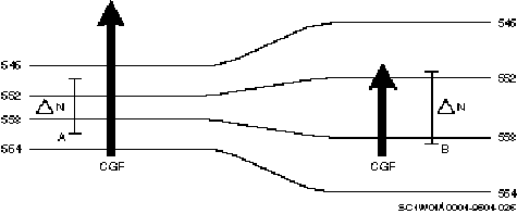
Figure 2–14. Different contour gradients.
CGF is directly proportional to the strength of the contour gradient. If the contour gradient increases, then the CGF also increases. Conversely, if the contour gradient decreases, then the CGF decreases. Figure 2–14 shows an example of two different contour gradient forces. Notice on the left side of the diagram how the contours are closely spaced (tighter gradient) while the contours spread out on the right side (weaker gradient). The larger arrow indicates stronger CGF on the left while the shorter arrow indicates a weaker CGF on the right. Also notice how both CGF arrows point towards lower heights.
Coriolis force (CoF)
Discussed in detail earlier, this is the force that causes any mass moving free of the Earth’s surface to be deflected from its intended path. The deflection is to the right in the Northern Hemisphere and to the left in the Southern Hemisphere. Deflection due to coriolis is greatest at the poles and is directly proportional to speed of the mass.
Centrifugal force (CeF)
Also discussed in detail earlier, this force is the equal and opposite reaction to any center-seeking force. Its strength is directly proportional to speed and radius of rotation.
Frictional forces (Fr)
This force directly opposes and retards the motion of one mass in contact with another. The strength of the force depends on the nature of the contact surface. The more irregular the contact surface, the greater is the frictional force. Therefore, air moving over water is least affected by friction; air moving over mountains is most affected by friction. At heights greater than 3,000 feet above the surface, friction has little effect on air movement. Friction always acts opposite to the direction of motion. With an increase in friction, the wind velocity decreases.
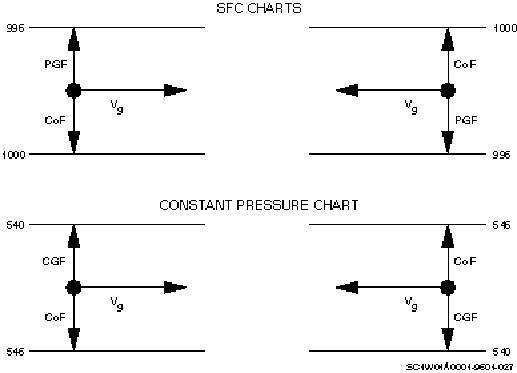
Figure 2–15. Geostrophic flow.
Each force above has an effect on the flow pattern in the Earth’s atmosphere. The two forces having the greatest effect on winds are pressure gradient force and coriolis force. The PGF initiates the horizontal movement of air. As the air starts its motion toward lower pressure, CoF force deflects it to the right. When these two forces are equal, the resulting flow is at right angles to PGF/CGF—this is called geostrophic flow (fig. 2–15). Notice the flow is parallel to lines of equal pressure (isobars/contours) with lower pressure/heights to the left of the direction of flow (V). This is the basis for Buys Ballot’s law that states—"In the Northern Hemisphere, if the wind is at your back, lower pressure is to your left and higher pressure is to your right."
Figure 2–16. Effects of friction on geostrophic flow.
Wind tends to follow the geostrophic pattern (parallel to the isobars) until an imbalance occurs between PGF and coriolis force. Friction is one possible cause for this imbalance to occur. When friction is present, speed is reduced, which lessens the effect of coriolis. Since coriolis is now weaker than PGF, air moves across the isobars toward lower pressure (Vg). Figure 2–16 shows an example of PGF without friction and an example with friction. Friction causes both CoF and CeF to decrease.
Figure 2–17. Effects of friction in the vertical and horizontal.
Winds tend to back in direction and slow with an increase in friction. For example, if an aircraft were descending from 2,000 feet down to the surface (using the diagram on the left of fig. 2–17), the winds would change from a west-southwest wind to a southwest wind and decrease in speed due to increased friction. Conversely, if the aircraft were ascending from the surface to 2,000 feet, the winds would veer and increase speed.
Circulation around pressure systems
As we stated before, air tends to flow parallel to lines of equal pressure. This is true even if isobars are curved around high- and low-pressure centers. Curved flow that is parallel to isobars is called gradient flow. Gradient flow, due to its curvature, has the added effect of CeF. To illustrate gradient flow, we examine the balance of forces involved with the two types of pressure circulations.
High pressure
Air moving around high pressure is termed anticyclonic circulation. In the Northern Hemisphere, anticyclonic circulation is clockwise rotation. To get anticyclonic gradient circulation (Va), there must be a balance of CoF against PGF and CeF. This occurs if the pressure gradient is constant around the high-pressure center. Figure 2–18 shows the balance of forces for gradient anticyclonic circulation. Also, notice the equal spacing of the circular isobars in the figure. This represents an equal pressure gradient around the pressure center.
Figure 2–18. Gradient high-pressure circulation.
If friction affects circulation, air speed is reduced, which again decreases the effects of CoF. Then, as with geostrophic flow, the CoF can no longer balance the PGF and air moves across the isobars toward lower pressure. This is divergent flow—it is diverging or flowing away from the pressure center. Examine figure 2–19 closely to understand the balance of forces associated with divergent anticyclonic circulation.
Figure 2–19. Divergent high-pressure circulation associated with friction.
Low pressure
Low pressure, or cyclonic gradient circulation (Vc), is the exact opposite of high-pressure gradient circulation (Va), with PGF directed inward. Were it not for CoF, air movement would be directed toward the low center. Still, CoF deflects the movement of air to the right of PGF, resulting in a counterclockwise rotation. As with high-pressure circulation, if we discount friction, the forces balance and a gradient flow circulation results. Notice CoF and CeF now balance against PGF (fig. 2–20).
Figure 2–20. Gradient low-pressure circulation.
When we add friction, as we show in figure 2–21, velocity is again reduced, lessening the effect of CoF. The result is the PGF overcomes the CeF and CoF with flow spiraling inward toward the center of the low. This inward directed flow is known as convergent, cyclonic circulation.
Figure 2–21. Convergent low-pressure circulation.
Confluence
Confluence is the merging of wind flow into a common axis of flow (fig. 2–22). As the flow compresses, the air parcels are constricted to a smaller area. Much like putting your thumb over the end of a garden hose, the velocity of the parcels increase.
Figure 2–22. Confluence.
Difluence
Difluence is the spreading apart of wind flow from a common axis. The effect is similar to removing your thumb from the end of a garden hose; the velocity of the parcels decrease. (See figure 2–23.)
Figure 2–23. Difluence.
Supergradient winds
A supergradient wind (Vsuper) is a wind which is adjusting to a rapid decrease in CGF downstream. The terms upstream and downstream can be a little confusing; so here’s an example to clarify them. If you were rafting down a river, upstream would be where you came from, while downstream would be where you are going. Now, let’s get back to supergradient winds. The wind temporarily exceeds that of the new, weaker CGF. Supergradient winds occur in areas of difluence where the CGF rapidly decreases. Due to the linear momentum, the air parcels decelerate slowly (temporarily creating an unbalanced situation) and a deflection to the right of flow occurs. (See top diagram figure 2–24.) The bottom diagram of figure 2–24 shows a situation where supergradient winds would occur. Notice how the stronger winds upstream are moving into an area of weaker winds.
Figure 2–24. Supergradient wind forces.
CoF causes the deflection because it remains stronger than CGF (or PGF if we were looking at surface features) and remains stronger until the winds slow to the new gradient speed. As the winds deflect towards higher heights, the parcels are converting kinetic energy to potential energy. What do we mean by kinetic and potential energy? First, we must understand the variable relationships of kinetic and potential energy.
Kinetic energy
Kinetic energy is energy resulting from motion and is directly proportional to mass and velocity. If the mass or velocity of an object is increased, the kinetic energy increases. Conversely, if the mass and velocity of an object are decreased, its kinetic energy decreases.
Potential energy
Webster’s Dictionary defines potential energy as energy that is the result of relative position instead of motion. It is directly proportional to mass and height. If the mass or height of an object are increased, the potential energy increases. Conversely, if the mass and height of an object are decreased, its potential energy decreases.
In our discussion of Vsuper we stated that parcels are deflected towards higher heights. Therefore, the potential energy increases due to the parcel moving towards the higher heights. We also stated that the winds slow to the new gradient speed. Therefore, kinetic energy decreases due to the velocity decreasing. The process is completed as a conversion and is not an abrupt change from one energy to the other. This is how Vsuper convert kinetic energy to potential energy.
Subgradient winds
A subgradient wind (Vsub) is a wind adjusting to a rapid increase in CGF (or PGF) downstream. It is temporarily weaker than that of the new, stronger CGF (or PGF).
Subgradient winds occur in areas of confluence and are in the process of accelerating. Air parcels convert potential energy to kinetic energy by turning towards lower heights or pressure. As potential energy decreases, the kinetic energy increases and the wind crosses contours at slight angles towards lower values. The bottom diagram of figure 2–25 shows slower winds upstream from the stronger winds downstream.
Figure 2–25. Subgradient wind forces.
The deflection to the left is caused by the increase in CGF (or PGF). CGF (or PGF) increases immediately upon entering a confluent area and remains stronger than coriolis force until winds increase speed to new gradient speed. While the winds are subgradient, they deflect to the left toward lower heights (or pressure) because of an imbalance of forces between CGF (or PGF) and CoF.
Cyclostrophic wind
Cyclostrophic wind (Vcyc) is a wind that occurs when CGF (or PGF) is balanced by CeF. CoF is negligible when compared to CGF (or PGF) or CeF. This circulation can only exist around low pressure areas where CGF (or PGF) is exactly opposite CeF. (See figure 2–26.)
Figure 2–26. Cyclostrophic forces around a low.
This circulation cannot form around a high-pressure area because CGF (or PGF) and CeF both point in the same direction. (See figure 2–27.)
Figure 2–27. Cyclostrophic forces around a high.
Some examples of cyclostrophic wind flow in the atmosphere include hurricanes, tornadoes, dust devils, and waterspouts. Hurricanes occur in the Tropics where CoF is small.
In the mid-latitudes, some systems with a very strong PGF and a small radius of rotation result in a large CeF, often forming dust devils, tornadoes, or waterspouts. Due to the extreme PGF (or CGF), either clockwise or counterclockwise flow is possible around these small-scale, low-pressure systems. CoF is only a very small part of the balance of forces since CeF and PGF (or CGF) are very large.
The actual wind is difficult to observe accurately because of the many disruptions to the flow (gust, eddies, turbulence, vertical motion, etc.) and our observation limitations.
025. Earth’s circulation systems
The distribution of land and water over the surface of the Earth alters the general circulation pattern. The unequal distribution of land and water masses amplifies the effects of unequal heating of the Earth’s surface. In addition, the belts of high and low pressure described earlier are actually broken into separate cells of high and low pressure. Besides these semipermanent features, a system of migratory pressure systems contributes to the general atmospheric circulation system.
Semipermanent pressure systems
Semipermanent pressure systems are largely the result of the general circulation pattern. They are called semipermanent because they can usually be found at the same place with the same intensity during the same month each year. You should become familiar with several of these semipermanent high- and low-pressure systems.
Semipermanent highs
The belts of high pressure described as existing near 30° in both hemispheres are actually divided into distinct circulation centers. These centers comprise the subtropical ridge. The locations of the centers of these large anticyclonic circulations are over the oceans between the continents. In the Northern Hemisphere there are two: (1) the North Pacific high, located over the Pacific Ocean to the west of California and (2) the North Atlantic or Azores high, located west of the African coast near the Azores. A third high-pressure circulation exists southeast of the United States near Bermuda. This circulation, an extension of the North Atlantic high, is called the Bermuda high. The locations of the three Southern Hemispheric subtropical highs are in the South Pacific, South Atlantic, and Indian Oceans.
Subtropical high-pressure systems exist throughout the year, though seasonal variations in location and intensity do occur. Circulation centers migrate north and south with the seasonal variation in the solar angle of incidence. The maximum intensity of these systems occurs in the summer months for their respective hemispheres. For example, the North Atlantic system is strongest in July, while the South Atlantic system is strongest in January.
There is another persistent type of high-pressure system in the Northern Hemisphere—the Siberian high. Unlike the subtropical systems, this high-pressure circulation system exists only during the winter. It is a low-level feature that forms because of the cold, dense air present in this region during the winter. This pressure system has its mean position at 50°N and is over central Asia.
Another common persistent high-pressure circulation is the Polar high. This high-pressure circulation is also the result of cold temperatures. Though its name suggests a center over the North Pole, its center varies with the seasons—usually displaced toward the area of coldest temperatures. During the winter months, it appears as an extension of the Siberian high. In the summer, it is situated near the cooler air of the North Pacific. This high is also called the Greenland or Canadian high.
Semipermanent lows
An area of low pressure is along the Equator. It is called the near-equatorial trough. It appears as an elongated area of lower pressure circling the globe. It exists due to strong equatorial warming and convergence of the northeasterly trade winds of the Northern Hemisphere and the southeasterly trade winds of the Southern Hemisphere. Its position varies with the seasonal change in latitude of direct solar radiation. The near-equatorial trough moves northward during the Northern Hemisphere summer and southward during the Northern Hemisphere winter.
There are three other semipermanent low-pressure circulations important to general circulation in the Northern Hemisphere—the Icelandic, Aleutian, and Asiatic lows. Two lows corresponding to the semipermanent belt of low pressure at 60°N are the Icelandic and Aleutian lows.
The Icelandic low is prevalent throughout the year. It is located in the North Atlantic near Iceland and Greenland. Its existence is due to cold temperatures of the ice caps of Iceland and Greenland contrasting to warmer water temperatures of the North Atlantic Ocean. This contrast is greatest in the winter; therefore, the Icelandic low is most intense then.
The location of the Aleutian low is in the Gulf of Alaska near the Aleutian Islands. Its presence is explained by a contrast in land and water temperatures, as was the Icelandic low. Yet, the Aleutian low is less persistent in the summer because of the influence of the Polar and North Pacific highs.
The Asiatic low dominates the entire Asian continent during the summer. The mean position of the center of this low is east of the Persian Gulf and just north of 23°. In this place, the Asiatic low dominates the same region as the Siberian high but in different seasons. The Asiatic low forms because increased summer heating in the Southern Asian Deserts replaces the cold Siberian high that dominates Asia in winter.
Semipermanent low pressure in the Southern Hemisphere is located in a somewhat continuous band around the globe at 60°S. This is very close to the pressure pattern suggested by the three-cell theory. This continuous belt exists because of a lack of significant land masses at this latitude in the Southern Hemisphere. In contrast, the Northern Hemisphere has a large concentration of land area in the latitudes around 60°.
The other areas of prevalent low pressure in the Southern Hemisphere are over the continents during January. These low-pressure circulations are the result of rapid heating of these land masses during the summer of the Southern Hemisphere.
Migratory pressure systems
Changes in the circulation pattern discussed thus far have been caused by seasonal changes in semipermanent pressure systems. Yet, the general circulation pattern of the atmosphere includes wind systems that continually migrate. Migratory systems comprise both anticyclonic (high-pressure) and cyclonic (low-pressure) circulations. They are responsible for the rapidly changing weather conditions found especially in the middle latitudes. This occurs because the migratory systems are responsible for the transportation of polar and tropical air into the middle latitude regions. When these two types of air with greatly different characteristics clash, the result is stormy weather, such as violent spring thunderstorms or heavy winter snowfalls. Usually, fair weather is associated with migratory high-pressure systems while stormy weather is associated with migratory lows.
By dictionary definition, tertiary circulations are circulations of a third order. In the atmospheric circulation system, tertiary circulations are small-scale wind systems that occur with the general circulation pattern. They are a result of the Earth’s rough surface and temperature differences between land and water.
Tertiary circulations are frequently called local winds and have names that link them to the place where they occur. In spite of their many names, we can lump tertiary circulations into four categories—local-cooling, local-heating, adjacent heating/cooling, and forced circulation winds.
Local-cooling winds
Local-cooling winds are the result of differing specific heats of land surfaces in a generally small place. These are nighttime circulations that develop as one surface radiates heat energy and cools faster than another, such as the mountain breeze shown in figure 2–28. At night, the rocky slopes of the mountain lose their heat more rapidly than the moist, vegetation-covered surfaces in the valley. Air in contact with the mountain cools and becomes denser than the valley air.
Figure 2–28. Mountain breeze.
This density difference causes a pressure gradient to form with high pressure on the mountains and low pressure in the valley. Winds then blow in the direction of PGF, down the slopes into the valley. Wind speeds associated with this type of wind rarely exceed 15 knots, even with a well-developed breeze.
Local-heating winds
Local-heating winds are the result of differential heating of two surfaces. Since it is due to local heating, it is a daytime feature dependent on incoming solar radiation. The reverse of the mountain breeze, the valley breeze, illustrates this type of wind (fig. 2–29). In the valley breeze situation, the Sun’s rays strike the mountain slopes before they strike the valley surfaces. Thus, the mountains warm quicker than the valley and lower pressure forms on the mountains. Now the PGF is directed up the slopes and the breeze blows from the valley to the mountain. The valley breeze is usually a more developed wind than the mountain breeze and reaches its maximum intensity in the mid-afternoon.
Figure 2–29. Valley breeze.
Adjacent heating/cooling winds
Land and sea breezes illustrate the adjacent heating/cooling winds shown in figure 2–30. Since land masses absorb and radiate heat three times faster than water masses, land is warmer in the daytime and cooler at night. Differential heating of the land and water causes lower pressure over the warmer land and higher pressure over cooler water. Therefore, PGF is directed toward the land from the water. Thus, on a coast or shoreline, sea breezes (coming from the water) would be expected in the afternoon. At night, the system reverses itself as the land cools more rapidly than the water. Therefore, higher pressure exists over land than the water and the PGF is directed offshore. The best-developed land breeze occurs just before dawn.
Figure 2–30. Land and sea breeze.
The entire pattern depends on the fact that land and water heat and cool at different rates. The sea breeze reaches maximum velocity between 1400 and 1600 local time and is much stronger than the land breeze. Sea breezes may be felt as far inland as 25 or 30 miles. The sea breeze is also a major factor in afternoon thunderstorm development along coastal regions. Cool air blowing inland creates a boundary (sea-breeze front) between cool, moist marine air and warm inland air. The sea-breeze front is often seen in Florida during the summer. Land and sea breezes are also common along rivers and lake shores.
Forced circulation
Forced-circulation winds are circulations that intensify because of terrain, usually mountain ranges. There are two types of winds in this category—the fall wind and the foehn.
Fall winds
Fall winds (sometimes called glacier winds) are cold downslope winds that remain colder than the air they replace in the lowlands. Fall winds are extremely strong and gusty (60 to 100 knots) and often cause considerable damage. These winds begin in the highlands where air is trapped over cold, snow-covered regions until forced downslope by a migratory pressure system. The winds move down the mountain slope and intensify as they move through the valleys. They are most violent in winter and spring, with single occurrences lasting for several days. Fall winds are frequently called Mistrals, the name of the local wind in the lower Rhone valley of southern France. Another name for a fall wind is the Bora that blows from the mountains of Yugoslavia to the Adriatic sea.
Foehn winds
The foehn wind, called the chinook in North America, is also a downslope wind, but foehn winds are warm and dry. The drying results when air is forced up the windward side of a mountain. This rising air cools and loses its moisture due to condensation. It then continues over the crest of the mountain and down the slopes, warming adiabatically as it compresses in the lower elevations. The result is a warm, dry wind that blows downward along the leeward slopes of the mountain. A foehn wind may raise the temperature as much as 50°F in the low lands on the leeward side of a mountain. The temperature increase may occur in as little as a few minutes. Figure 2–31 shows the sequence of events for a foehn wind and the clouds that you may observe on the windward side and near the peaks of the mountain. Notice the absence of cloudiness on the leeward side of the mountain. Expect this since the air loses its moisture through condensation as it is forced up the windward side.
Figure 2–31. Foehn (chinook) wind.
Though considered a local wind, the foehn wind can be a hazard to aviation. This is the case when the wind direction is perpendicular to the mountain and the wind speed increases rapidly with height. This causes extremely turbulent conditions above the peaks and leeward of the mountains. This condition may be detected by the presence of cap, rotor, and lenticular clouds as depicted in figure 2–32. Also notice in the figure the wind currents associated with mountain-wave conditions.
Self-Test Questions
After you complete these questions, you may check your answers at the end of the unit.
023. Thermal and three-cell circulation
1. Briefly describe conditions that cause a single-cell circulation pattern.
2. What is the main driving mechanism responsible for the Earth’s large-scale atmospheric circulations?
3. Match the characteristics of each of the three circulation cells in column B with the name of the cell in column A. Items in column B may be used more than once.
Column A |
Column B |
____1. Strong easterly surface winds are found beneath this cell. ____2. A strong coriolis force sharply alters wind direction. ____3. Circulation in this cell is interrupted by the exchange of polar and tropical air. ____4. The cell most responsible for subtropical belt of high pressure. ____5. Northeast trade winds are found beneath this cell. ____6. The cell dominated by westerly flow at the surface and aloft. ____7. Strongest of the three cells. ____8. Generally located between 30 and 60°. ____9. The cell created by rising equatorial air. ____10. Mean position is between 60 and 90°. ____11. Upper-level flow in this cell is deflected eastward. |
a. Hadley cell. b. Polar cell. c. Ferrel cell. |
024. Forces affecting Earth’s general circulation
1. What are the four forces that dictate the general circulation pattern?
2. Which force starts the horizontal movement of air over the Earth’s surface?
3. Describe contour gradient force.
4. What kind of flow is created when pressure gradient force (PGF) equals coriolis force (CoF)?
5. What does Buy Ballot’s law states?
6. What can a pilot expect the wind direction and speed to do as the aircraft descends into an area with rough terrain? Why?
7. What is the difference between confluence and difluence?
8. Where do winds deflect towards in a supergradient wind condition and what is happening to the air parcels?
9. A hurricane is an example of what kind of wind?
025. Earth’s circulation systems
Identify each of these described pressure systems as semipermanent or migratory and as a high or low type of pressure system.
1. Dominates the Atlantic Ocean west of Africa.
2. Most prevalent over the oceans of the Southern Hemisphere during January.
3. Dominates Asia during the winter.
4. Located in the North Atlantic Ocean near Greenland.
5. Dominates the continents of the Southern Hemisphere during January.
6. In the summer it is located east of the Persian Gulf near 23°N.
7. The influence of the Polar high makes it less prevalent in the summer.
8. Fair weather is associated with this system in the middle latitudes.
9. Lack of land masses near 60°S allows this to remain as a somewhat constant belt of pressure.
10. Found as an extension of another feature and is located off the Southeast Coast of the United States.
026. Tertiary circulations
1. What are the four categories of tertiary circulations?
2. What is the nocturnal wind that flows into valleys and to what category of tertiary circulation does it belong?
3. Identify the wind caused by warming air near the mountain slopes and to what category of tertiary circulation does it belong?
4. In which tertiary circulation category are land and sea breezes?
5. The Mistral and Bora belong to which category of wind?
6. What category of wind is the fall wind?
7. Cap, rotor, and lenticular clouds are characteristic of which forced-circulation wind?
The discovery of the jet stream during the closing days of World War II introduced insights on the general atmospheric circulation. Jet streams now are recognized as potent forces for inducing cyclogenesis, tornadoes, squall lines, mountain waves and turbulence. Regions where jet streams are not present tend to have more uniform and less violent weather.
The jet stream awareness also improved our understanding of the mid-latitude climatic structure and enabled forecasters to strengthen the reliability of both short-range and long-range prediction procedures.
027. General structure of jet streams
We can best describe the basic structure of a jet stream as a river flowing horizontally through the atmosphere. They are normally thousands of miles in length, hundreds of miles wide, and a few miles deep. Wind speeds in a jet stream vary along each of its dimensions. Looking into the spiraling column in the direction of flow, you can see the change in speed across the jet stream width and through its height (fig. 2–33). The greatest wind speeds through the jet stream are in the core within the interior of the jet stream. Notice the displacement of the core to the left and top within the jet stream. Therefore, change in wind speed over distance (speed shear) is greatest above and to the left of the jet stream core as you look in the direction of flow.
Figure 2–33. Cross section of jet stream.
The core of the jet stream, found along its length, defines the jet stream axis (fig. 2–34). Notice, the axis is drawn along the band of maximum winds when we view it from the top. The figure also shows the variation in wind speed along the length of a jet stream.
Figure 2–34. Jet stream axis and maxima.
Jet maxima (maxes) or jet streaks are intermittent regions of the strongest wind speeds within the jet. The isotachs which define the jet maximum are elliptically (football) shaped, both horizontally and vertically. (See figure 2–35.) Core speeds of 100 to 150 knots are common within jet maxima, but speeds up to 300 knots have been observed. Jet maxima are not stationary features but really move along the jet stream axis. The importance of jet maxima comes from their link with other atmospheric disturbances.
Figure 2–35. Examples of jet maxima.
The jet stream is a narrow belt of strong winds in the upper troposphere with speeds of 50 to 200 knots. In the Northern Hemisphere, these winds usually have a westerly component. Jet stream position varies between different latitudes and elevations around the Earth. It even varies in latitude and elevation within a small geographical area. The jet stream may appear as a continuous band around the Earth, but more often it gradually diminishes at one or more points and then reappears farther downstream.
Jet stream wind shear
The jet stream is significantly wider than it is deep. Though the core may be more than 100 miles wide, it may be at least 10,000 feet thick. This produces stronger vertical wind shears than horizontal shears.
Vertical
Winds in the jet core average 120 to 150 knots during the winter, with frequent occurrences above 200 knots. Since the increase to these high speeds occurs in a comparatively short distance, the shear values are also high. The highest vertical shear usually occurs above 500mb.
Shear above the core is usually greater than the shear below the core because on the average the wind gradient is greater above the core. The wind usually decreases 50 percent within 5 km above the core, but takes 5.5 km to decrease 50 percent below the core.
Horizontal
Cross sections of the jet stream also indicate horizontal wind shear. There is a rapid decrease of wind speed on each side of the jet core. This decrease can be as much as 100 knots in 100 miles on the north side and 100 knots in 300 miles on the south side. This indicates greater horizontal shear and turbulence north (cold air side) of the jet. (See figure 2–36.)
Figure 2–36. Jet stream wind shear.
Jet stream systems
A jet stream rarely occurs alone in the atmosphere; multiple jets are the rule. Two major jet streams are frequently observed: the polar front jet and the subtropical jet. Figure 2–37 shows the average position of these two Northern Hemisphere jet stream cores with respect to the tropopauses. The jet core depicted between the polar and mid-latitude tropopauses is called the polar front or mid-latitude jet.
The core between the mid-latitude and tropical tropopauses is called the subtropical jet.
Figure 2–37. Relative position of jet cores.
A third jet stream, called the arctic or polar night jet stream, is believed to occur during the winter at 75°N around the 300- to 350-mb level near the Arctic circle. It is most often observed in the winter, hence the name polar night. In addition to these three jets, the tropical easterly jet is located over southern Asia and northern Africa. This jet is most frequently observed in the summer at the 150-mb level. In the following discussion, we focus our attention on the two major jet streams affecting the Northern Hemisphere—the polar and subtropical jet streams.
Origins of jet streams
Jet streams are primarily caused by two reasons. One origin of a jet stream is caused by a large horizontal temperature contrast associated with a large thermal wind vector. Jet streams that form by this large temperature contrast have a jet axis that is at the tropopause because this is where the contour gradient force is at a maximum. Above and below the tropopause, the slope of the constant-pressure surface weakens. Horizontal temperature contrast is the primary originator of the polar front jet stream.
The second origin of a jet stream is due to the conservation of angular momentum. Newton’s first law of motion states that an object at rest tends to stay at rest and an object in motion tends to stay in motion at the same velocity (be conserved) until it is acted on by an outside force.
Angular momentum is the product of the mass times velocity and radius of rotation for an object, or parcel, following a curved path. It is stated by the formula:
AM = m × v × r
where:
AM = Angular momentum
m = mass
v = velocity
r = radius
Angular momentum is conserved for an object when forces acting upon the body are in balance. If the mass is held constant and the radius decreases, then the velocity must increase in order to conserve angular momentum. This is known as an inversely proportional relationship. Our earlier example pertaining to a ball on the end of the string may help explain this. If you have a ball on the end of a string and you spin it around your finger, the string begins to wrap around your finger. As the string wraps around your finger, the length of string decreases (decreasing the radius) and, ultimately, the ball spins faster (increasing its velocity).
Because the atmosphere is a fluid and not attached to the solid Earth, it tries to conserve its angular momentum. As a parcel moves poleward, the radius (of the Earth) decreases with an increase in latitude, causing its velocity to increase. Conversely, with a parcel flowing equatorward, the radius increases with a decrease in latitude; as a result, its velocity decreases.
028. Polar front jet (PFJ) stream
The PFJ is the primary jet stream in the middle latitudes of the Northern Hemisphere. It may appear as a continuous band around the globe, but, more often, it vanishes at one point and reappears downstream. Its disappearance and reappearance is often due to variations in its height. Its existence can be attributed to large horizontal temperature differences (thermal gradient) across the upper and middle latitudes. These temperature differences exist not only at the surface, but vertically to the tropopause. The stronger the thermal gradient, the stronger is the jet stream.
Figure 2–38. Polar jet and tropospheric leaves.
Vertically the PFJ is at the top of the troposphere near the tropopause zone. In fact, the polar jet divides the tropopause into two segments called leaves (fig. 2–38). The PFJ is within the warm air, south of the coldest air. It frequently marks the boundary between cold polar air and warmer subtropical air. In the summer, with temperature differences lessened by warming in the middle and higher latitudes, the PFJ is found at higher latitudes. When the middle and higher latitudes cool in winter, the polar jet migrates farther south. Winter is also the time of greatest horizontal temperature differences between latitudes and the time when the PFJ’s speeds are greatest.
The PFJ follows a generally eastward track; still, if you view the entire pattern outlined around the globe, you should notice large north to south undulations. The undulations, called long waves, consist of large low-pressure troughs and high-pressure ridges. The series of waves the jet stream follows is the long-wave pattern. Observations reveal the series of long waves created by this flow number as few as three and as many as seven around the globe—the average number found is five (fig 2–39).
Jet maxima in the PFJ are of prime importance to the meteorologist because of their link to mid-latitude migratory pressure systems. PFJ maxima cause and steer the major mid-latitude tropospheric pressure systems. Low-pressure systems are found ahead of the maxima while high-pressure systems move behind them.
A valuable clue in locating the PFJ is the relationship between the jet stream and the polar front. The core of the PFJ is directly above the isotherm ribbon associated with the frontal zone (thermal concentration) on the 500-mb surface. This relationship has a high degree of correlation, since troughs and ridges slope very little between 500 and 300mb and have almost no slope from 300 to 200mb.
There are several methods of locating the 500-mb frontal zone. The simplest is to locate the position of the –17°C isotherm. The polar front usually cuts the 500-mb surface along the –17°C isotherm. The concentration of isotherms are located to the warm side of the transition zone, with the largest concentration between –17 and –20°C.
The other methods usually depend on locating areas of highly concentrated isotherms. A jet stream is usually associated with a thermal concentration of more than 10°C in 200 miles. Warm air is south of the concentration and cold air is north. Thus, with your back to the wind (facing downstream), the cold air is to your left and the warm air to your right.
Since the temperatures reverse above the tropopause, in a north-south direction, the jet stream will be just below this temperature reversal. This reverse occurs above 200mb. Thus, the jet stream core is usually located between 300 and 200-mb levels.
From these observations come the following rules:
029. Subtropical jet (STJ) stream
Another jet stream important to the Northern Hemisphere is the subtropical jet (STJ) stream. It exists independently, but frequently exists with the PFJ.
Two main factors contribute to the formation of the STJ. The first is the convergence of the Hadley and Ferrel Cells as previously discussed in atmospheric circulation. The second factor is the horizontal temperature contrast due to the interaction of warm, moist subtropical air and cold dry polar air.
The STJ position is south of the polar front jet and is normally observed between 25 and 30°N, with a mean latitude of 28° N. It extends from the Hawaiian Islands eastward to southern Florida. Conservation of angular momentum is a factor that accelerates the subtropical jet, while coriolis force causes recurvature to the right. Remember, as the jet moves northward, radius decreases and velocity increases. At the same time, coriolis force is also increasing as it moves closer to the poles, thereby increasing curvature.
We can trace the STJ’s axis around the entire globe. In contrast to the polar jet stream, the STJ persists at the 200- to 150-mb level. Though the STJ persists at higher altitudes than the polar jet stream, STJ winds as high as 120 knots have been observed as low as 300mb, but rarely below this level. The STJ reaches its maximum speed at its farthest projection poleward. Reference figure 2–37, which shows the relative vertical and horizontal positions of the STJ and PFJ’s. Notice the STJ also divides the tropopause into leaves with the tropical leaf to the south and the mid-latitude leaf to the north.
The STJ typically flows more directly from west to east. At times, the subtropical jet moves northward and merges with the polar front jet but is more often observed as a separate feature. However, when these two jet streams do interact, favorable conditions for extreme turbulence exist. This condition also favors the development of severe thunderstorms, as satellite imagery often confirms severe weather activity as a characteristic wedged-shaped cloud pattern in this region. The STJ is very important in transporting warm moist air poleward to interact with cool dry polar air. This produces strong temperature, contour, and isotach gradients associated with severe weather.
It is in the region of confluence of the polar and subtropical jet streams where the STJ velocities are the greatest. This occurs partly because the STJ axis is at its furthest poleward extent and, consequently, the radius of the Earth is smaller (conservation of angular momentum). Also, the confluence of the STJ with air already moving at high speeds in the PFJ results in producing a broader and stronger jet stream.
The STJ is less connected with lower tropospheric pressure systems than the PFJ. Occasionally, it does become superimposed on a lower tropospheric pressure system and can exert considerable influence on the pressure system’s development. Just like the PFJ, the STJ also has seasonal variances, being stronger in the winter than in the summer, and typically weak during hurricane season.
030. Life cycle of a jet stream
Jet streams undergo a distinct life cycle consisting of a period of organization and one of disintegration. Their horizontal structure, as it appears on upper-level products, depends on the phase of this life cycle. When the jet is well organized, the longitudinal axis follows the pattern of long waves. Also, its amplitude is comparable to that of the 300-mb contours. Thus, the jet stream can provide a clue of the long-wave pattern.
Figure 2–40. Jet stream configuration on constant-pressure surface.
Figure 2–40 shows a 300-mb product with the contours removed to emphasize the horizontal structure of the jet stream. A lack of uniformity in wind speed along the jet stream axis is clear in the isotach analysis. As shown, the wind gradient along the axis is sharp and the wind speed difference between the maximum and minimum approaches 100 knots. Often, the difference between individual maximum centers exceeds 100 knots.
Figure 2–41. Organized jet stream over western United States displaying jet fingers (disorganized jet) over central and eastern states.
During disorganized periods, the well-defined wind speed concentrations of 50 knots or more tend to disappear. When this occurs, the westerlies either break into closed circulation patterns or show comparatively uniform velocities throughout the middle latitudes. The westerly wind speed pattern during periods of dissipation is characterized by the development of many, comparatively weak "jet fingers," often no more than 300 to 400 statute miles apart. Figure 2–41 shows a 300-mb product with "jet fingers."
The jet stream follows the contours closely. Small departures are often noted, however, when the wind speed increases suddenly in a region of comparatively weak contour gradient or decreases suddenly in an area of strong contour gradient.
Diverging contours downstream cause the jet to deflect toward greater heights (higher pressure at the same altitude) and converging contours downstream tend to turn the jet toward lower heights.
The isotach maxima that occur along the axis of the jet stream are related to the short-wave troughs in the westerlies and their connected surface systems. The maxima usually move near the speed of these waves (average 35 to 40 knots). Distances between maxima vary from about 10 to 25 degrees longitude and speeds may reach 250 knots.
The maxima tend to be closed, symmetrical, lenticular-shaped isotachs that keep their shape over short periods. They undergo definite life cycles with periods of formation and decay, which often may be followed on synoptic products. Figure 2–42 illustrates the life cycle of a fully organized jet stream. Beginning with a balanced symmetrical arrangement of isotachs along the jet stream axis (fig. 2–42, view A), the isotachs downstream from the maxima centers are displaced faster than those behind the center (fig. 2–42, view B). In addition, high-speed isotachs are displaced faster downstream than slower ones. This increases the area enclosed by the highest valued isotach and packs the isotachs downstream from the maxima centers (fig. 2–43, view C). The maxima merge with the low-speed area downstream and the low-speed area disappears (fig. 2–42, view D). The resulting pattern leads back to the beginning stage (fig. 2–42, A), and the cycle is repeated. For a jet stream on the decline, the condition shown in figure 2–42, view C, is followed by that in figure 2–42, view E, rather than 2–42, view D. This stage is the first indication of the disintegration of the jet stream and its breakup into jet fingers.
Occasionally, the jet stream surrounds the Earth as a continuous band, but usually diminishes gradually at one or more points. It then reappears in a new location. This new appearance is often connected with migration of the jet stream.
The jet stream can migrate due to changing orientation at speeds near 10 knots, but it does not, at any time, move perpendicular to its axis. This movement usually is to the north or south.
Basically, the jet stream follows the migration of the Sun. Its mean position advances south in winter and retreats toward the poles during summer. The average latitude of the jet stream in the Northern Hemisphere is 35 to 40°N in winter and 42°N in summer.
In a jet migrating north, a west wind maximum usually emerges from the Tropics and gradually moves through the lower mid-latitudes. Another maximum, initially located in the upper mid-latitudes, advances toward the Arctic Circle and weakens. The jet stream is usually well-organized and the contour pattern shows troughs extending into low latitudes.
As the jet progresses northward, the amplitude of the long waves decreases and cut-off lows, south of the prevailing westerlies, dissipate.
The jet stream moves southward until the long-wave amplitude reaches a critical limit. At this stage, the jet usually disintegrates. Also, at this point, cut-off, closed lows frequently form in the southern portion of the troughs. This reestablishes a zonal flow now farther to the north and a new jet stream forms to start another cycle.
031. Jet stream and migratory pressure system relationships
Cyclones and bad weather tend to be associated with jet streams. This is especially true for weather associated with a warm front in the formative and mature stages of a cyclone.
You learned before that the mid-latitude jet usually lies directly above the 500-mb position of the polar front. Using average frontal slopes, this places the jet stream about 300 miles behind the surface cold front and about 600 miles ahead of the surface warm or stationary front.
For instance, the following rules apply:
Four cloud patterns are usually associated with the jet stream:
These cloud patterns often extend from horizon to horizon and move very rapidly. Clouds occur most frequently in the following positions:
By far, most clouds are on the equatorward side of the jet. Most of the time, clouds are not observed above the jet core.
The greatest occurrence of precipitation usually straddles the jet axis, with a slight bias toward the poleward side.
Self–Test Questions
After you complete these questions, you may check your answers at the end of the unit.
027. General structure of jet streams
1. Briefly define a jet stream.
2. How does the jet stream vary in latitude and altitude around the world?
3. Two major jet streams are frequently observed. What are they?
4. Of the horizontal or vertical wind shears associated with the jet stream, which is the stronger?
5. Where does the greatest vertical wind shear occur with respect to the jet core?
6. Where does the greatest horizontal shear occur with respect to the jet core?
7. Match the jet stream systems in column B with the characteristics in column A. Systems may be used once, more than once, or not at all.
Column A |
Column B |
____1. Jet stream found near the Arctic Circle. ____2. Observed in the latitudinal range of 25 to 30°N near the 150-mb level. ____3. Jet stream which divides the tropopause into the polar and mid-latitude leaves. ____4. Summer time jet stream found over southern Asia and northern Africa at the 150-mb level. ____5. The jet streams which most affect the Northern Hemisphere. |
a. Polar front jet stream. b. Subtropical jet stream. c. Arctic/Polar night jet stream. d. Tropical easterly jet stream. |
8. What are the two primary causes of jet stream formation?
9. What is the primary originator of the polar front jet stream?
028. Polar front jet (PFJ) stream
1. In relation to the 500-mb surface, where is the polar front jet core usually found?
2. Along what isotherm does the polar front jet intersect the 500-mb surface?
3. At what altitude will you usually find the jet stream core during the winter?
4. The width of the jet core is approximately equal to what?
029. Subtropical jet (STJ) stream
1. What factor accelerates the STJ?
2. What might a wedged-shaped cloud pattern seen on satellite imagery over Texas indicate? What causes this pattern to occur?
030. Life cycle of a jet stream
1. For each of the statements below, indicate whether the jet would be organized or disorganized.
a. The longitudinal axis tends to follow the long-wave pattern.
b. The wind gradient along the axis becomes very strong (often exceeding 100 knots).
c. Jet fingers are formed often, and about 30 to 40 miles apart.
d. Well-defined wind speeds of 50 knots or more disappear.
e. The distance between isotach maxima is 10 to 25° longitude.
2. The following series of statements represent events during the cycle of a jet stream migrating northward. The statements are out of sequence. Arrange them in the proper sequence.
a. A west wind maximum emerges from the Tropics.
b. The jet stream is well-organized and often shows troughing into the low latitudes.
c. A second maximum, located in the upper mid-latitudes, moves northward and dissipates.
d. The amplitude of the long waves decrease and a classical high index situation exists.
e. Cut-off lows south of the prevailing westerlies dissipate.
031. Jet stream and migratory pressure system relationships
1. How will the jet stream lie in relation to an occlusion and to a cold front oriented north-south, with no associated warm front?
2. Where will the jet stream remain (north or south) in relation to an unoccluded wave cyclone?
3. Will the jet stream lie north or south of the low associated with an occluded front?
4. Will the jet stream parallel the direction of the warm sector isobars of a surface low?
5. Will the jet stream roughly parallel the isobars around the northern periphery of a warm (slow-moving) surface high?
6. When a cold surface high dissipates, what happens to the jet stream aloft?
7. List the four cloud patterns associated with the jet stream.
8. Where do clouds most frequently occur in relation to the jet core and the Equator?
9. Where do clouds most frequently occur in relation to the jet core and the poles?
10. Precipitation usually straddles the jet, with a slight bias toward which side of the jet?
Air motions within the atmosphere are normally very complex. However, sometimes a large portion of the atmosphere comes to rest (stagnates) or moves slowly over a uniform surface. When this occurs, the air within this portion of the atmosphere assumes the same thermal and moisture properties as the surface beneath it. These properties tend to be uniform over the entire mass of air.
When the mass of air is set in motion, it maintains these characteristics until it is modified by the surfaces over which it moves. Therefore, you must know where these air masses form, how they are formed, how they are modified, and the flying conditions they produce.
Three factors are considered necessary for the formation of air masses. First, there must be a surface with comparatively uniform properties, especially the properties of temperature and moisture. This surface may be water or land. Second, the air must stagnate over the uniform surface. Third, there must be a large divergent flow. This flow inhibits temperature contrasts and produces uniform characteristics throughout the air mass.
The stagnation of air over a surface of uniform conditions permits a condition of temperature equilibrium between the ground and air, actually the formation of the air mass. This is accomplished by:
By far the most effective and fastest transfer is the turbulent-convective transport of heat upwards. Least efficient and slowest is radiation. The equilibrium layer created by the turbulent-convective process has the greatest vertical depth, but layers resulting from radiation cooling are comparatively shallow. Evaporation and condensation contribute in each of the other two processes, but are very ineffective in creating air masses by themselves.
Anticyclonic systems are excellent for air-mass formation. They are usually stagnant or slow moving, which allows the air time to adjust its heat and moisture content to that of the underlying surface. They have a divergent airflow, which spreads the properties horizontally over a large area, with turbulence and convection distributing these properties vertically. These factors have the effect of creating uniformity throughout the air mass.
Two examples of the anticyclonic systems are the warm highs, Bermuda and Pacific, and the Siberian cold high. Warm highs extend to great heights, due to higher thickness aloft, and produce an air mass of comparatively large vertical extent. Cold highs have a moderate or shallow vertical extent and thereby produce air masses of moderate or shallow height.
Cyclonic systems are not conducive to air-mass formation. They are characterized by strong wind speeds that prevent the air mass from remaining over a surface long enough to become modified. Cyclonic systems also have a convergent windflow that creates temperature contrasts. The convergence creates ascending air, which causes the air to lose contact with the surface. Without this contact, the air cannot acquire the properties of the surface.
The world’s belts of convergence resemble the cyclonic systems. They also are not conducive to air-mass formation.
These characteristics decide the types of air masses forming in various areas of the world (source regions). Tropic regions are covered predominantly by water surfaces, thus providing the uniform surface.
Air masses in the polar regions form slowly through the loss of heat by radiation. The surface of the polar region is almost completely covered by snow, thus providing the needed uniform surface.
The temperate latitudes provide neither of the two factors needed for air-mass formation and rarely serve as source regions. Steep gradients of temperature and a large variance in the land/water distribution prevail in temperate latitudes. Instead of the temperate zone being a source region, the temperate zone is a transition zone. Air masses with different properties move in, clash, and produce a variety of weather.
There are two notable exceptions where air masses form despite the lack of proper factors. These are the air masses that form maritime polar air over the North Pacific between Siberia and North America and over the Atlantic water off Labrador and Newfoundland. Both areas have active and strong windflow, yet the air masses still form. This formation, however, is related to the characteristics of the region rather than the system.
The Glossary of Meteorology defines an air mass as a widespread body of air having properties identified by its horizontal composition—particularly temperature and humidity. Also, vertical temperature and moisture variations are about the same throughout the horizontal extent of a given air mass. Air masses should not be classified as a part of the secondary circulation, but air-mass properties, particularly along the boundary zone between contrasting air masses, cause circulation phenomena that are secondary in scale. This is the way we examine air-mass properties.
If atmospheric circulation was strictly zonal, we would find only two different air masses—polar and tropical. The boundary, or zone, between them is the polar front. This distribution is clear-cut in the middle and upper troposphere. At the surface, perturbations in the zonal flow confuse the picture. Horizontal turbulence, variations in insolation, and the motion of the air masses themselves invoke complicated transitional effects.
The considerable differences in the earth-atmosphere parameters influence the different sections of the atmosphere. Radiation rates, convection, evaporation, condensation, insolation, and turbulence are all functions of the Earth’s surface over which a given air mass may spend a large part of its time. Air masses over oceans acquire maritime characteristics: mild temperatures, considerable moisture (at least in the lower layers), moderate lapse rates, and a degree of conditional instability. Polar air masses tend to be very cold and dry with temperature inversions in the lower levels and fairly uniform lapse rates aloft. These examples serve to show that we should examine some source regions of the principal air masses. This enables us to better understand their characteristics.
We classify air masses with letter identifiers according to their source region and characteristics. The source region is considered the most useful criterion. Thus, the primary air-mass identifier refers to the source region. A capital P represents a polar air mass and tropical air masses are represented by a capital T. On occasions, arctic air-mass properties are important; a capital A identifies these air masses. Equatorial air masses are represented by a capital E. To further classify the source region, we make a distinction between land and water areas since these regions give decidedly different characteristics to overlying air masses. Use the letter "c" for continental or "m" for maritime surfaces; for example, cP indicates a continental polar air mass and mT a maritime tropical air mass.
The stability characteristics of air masses often depend on the temperature differences between them and the surfaces over which they may travel. The third category identifies whether the air is colder (k) or warmer (w) than the surface it is moving over. Therefore, "w" designates those that are warmer and "k" those that are colder than the surfaces over which they are found. This classification is relative and frequently difficult to determine. The several possibilities can be listed thus:
|
mPw |
mPk |
cPk |
cA |
|
mTw |
mTk |
cTw |
E |
We can explain the system as follows. mPw represents a polar maritime air mass that is warmer than the surface over which it moves. cPk describes a continental polar air mass that is colder than the surface over which it moves, and so on. We do not need all the categories for arctic air masses. They are usually continental in character and colder than the surface over which they move.
Continental and maritime designations signify the influence of the surface on air-mass properties. Arctic, polar, and tropical primary designations suggest the importance of latitude of the source regions. Typical k air masses have convective clouds, turbulent gusty winds, and good visibility. Heating of these air masses, by a warmer surface, increases the lapse rate and vertical eddies that favor convective transport. On the other hand, w air masses have their lower layers cooled by the colder surface. This tendency toward an inversion of the lapse rate increases stability. When present cloud systems are stratiform and vertical turbulence is suppressed, visibility is frequently poor with low-level radiation and advection fog the rule.
A word of caution is in order, however. The interaction of air masses with the surface is not the only mechanism that produces observed weather effects. Convergence, divergence, and subsidence are very important in finding lapse rates and stability. Dynamical processes frequently dominate the thermal effects.
We use a fourth letter to represent the stability of the air mass. An "s" signifies a stable air mass and "u" specifies an unstable air mass.
By combining these letters, we can obtain a relatively complete description of the air masses. A classification of cPws signifies a stable, continental polar air mass that is warmer than the surface it is moving over.
Figure 2–43. Fronts, pressure centers, and air-mass source regions (January).
Figure 2–44. Fronts, pressure centers, and air-mass source regions (July).
Figures 2–43 and 2–44, respectively, show January and July air-mass source regions. We’ll limit our emphasis to those air masses and source regions that influence the Northern Hemisphere weather.
Wintertime continental polar (cP) air masses
These have their source regions in central Canada and Siberia. Next to the extreme Arctic and Antarctic regions, these are the coldest places on Earth. This is because of the intense radiational cooling and lack of insolational heating in these source regions. The surface is completely frozen and is mostly snow and ice covered. Air masses in these regions are extremely cold and stable and are, therefore, very dry. Clouds are uncommon in the cP air masses, although ice fogs frequently form when temperatures fall below –40°F.
Summertime continental polar (cP) air masses
These have their source regions in the central portion of high-latitude continents. Insolational heating warms the surface substantially, even to the point of dissipating the snow cover and thawing the ground to a noticeable depth. Summertime cP air masses are cool and dry, but not necessarily stable. They are fundamentally changed forms of the wintertime cP air masses that have experienced insolational heating in their lower layers. Generally, their lapse rates are less steep than their wintertime counterparts.
Wintertime maritime polar (mP) air masses
We find these air masses over open oceans at high latitudes. The cool, moist air masses indigenous to this locale are mainly cP air masses that have moved out over the open ocean. The lower layers are substantially changed by the comparatively warmer, yet still cold, water surface. The mP air masses tend to be moist and unstable in the lower layers, and cold and dry aloft.
Summertime maritime polar (mP) air masses
These start in basically the same regions as the wintertime mP air masses. For the North American continent, these regions are the Gulf of Alaska and the North Atlantic. Summertime mP air masses resemble their wintertime counterpart; they are cool and moist in the lower layers, and cool and dry aloft. The overall temperature is somewhat higher than in the winter mP air masses. Instability is more general in the lower layers and abrupt change in the lapse rates is found in the moisture discontinuity aloft. An inversion at this level is not uncommon.
Wintertime maritime tropical (mT) air masses
We find these air masses over the open oceans, just south of the polar front, near 30°N latitude. Indeed, mT air-mass source regions extend southward across the near-equatorial trade wind convergence zone (NETWCZ) into the Southern Hemisphere. In North America, the source regions are the semipermanent subtropical high-pressure centers in the southwestern Caribbean. The mT air masses in winter are warm, moist and unstable. In the lower levels, the lapse rates frequently approach the dry adiabatic rate, and the lapse rates are usually steep up to the tropopause. Moisture is fairly well diffused to comparatively high levels.
Summertime maritime tropical (mT) air masses
These have the same source region as the wintertime mT air masses and, additionally, the Caribbean Sea. Those that influence North American weather originate in the semipermanent anticyclones that, during this season, are centered near 15°N latitude. mT air masses in summer are very warm and moist, and markedly unstable. Convective instability frequently occurs.
Continental tropical (cT) air masses
These air masses are relevant to North America only during the summer. The source region is confined to Northern Mexico and the extreme southwest deserts of the United States and are generally centered near 30° N latitude. The cT air masses are hot, dry, and very unstable. Because of this inherent instability, large-scale upward vertical motions occur. This in turn causes surface pressures to fall, forming weak surface circulations called heat lows. The upper levels (usually 700mb and above) are dominated by subsiding air associated with the convergence between the Hadley and the Ferrel cells.
If the various types of air masses remained permanently in their source regions and vertical motions were nonexistent, there would be little or no change in weather. Since air masses migrate, definite changes in their structure, called air-mass modifications, are a natural result. When an air mass moves out of its source region, several factors act on the air mass to change its properties. These changes are advection, radiation loss, thermodynamic and turbulent (mechanical) mixing, based on the process causing the changes. The table below lists the major processes and also shows the changes in stability you should expect with these processes:
|
The Process |
How it Happens |
Results |
|
1. Heating from below. |
Air mass passes from a cold surface to a warm surface, or surface under air mass is heated by Sun. |
Decrease stability. |
|
2. Cooling from below. |
Air mass passes from over a warm surface to a cold surface, or radiational cooling of surface under the air mass takes place. |
Increase stability. |
|
3. Addition of moisture. |
By evaporation from water, ice, or snow surfaces; moist ground; raindrops; or other precipitation which falls from overrunning saturated air currents. |
Decrease stability. |
|
4. Removal of moisture. |
By condensation and precipitation from the air mass. |
Increase stability. |
|
5. Turbulent mixing. |
Up-and-down drafts. |
Tends to result in a thorough mixing of the layer where turbulence exists. |
|
6. Sinking. |
Movement down from above colder air masses or descent from high elevations to lowlands, subsidence, and lateral spreading. |
Increases stability. |
|
7. Lifting. |
Movement up over colder air masses or over elevations of land or to compensate for air converging at the same level. |
Decreases stability. |
Advection
As air masses move away from their source regions they carry with them physical characteristics acquired from their long residence in the region. We can call these the initial conditions of vertical temperature profiles (lapse rates) in other terms such as moisture content and its distribution, mean temperature, vorticity, and wind velocity. Most of the variations in the parameters are found in the vertical distributions. Air masses are strikingly homogeneous throughout their horizontal extent. The horizontal motion of the air mass does not directly affect changes in temperature and moisture content or lapse rates. This is exclusive of the equatorial regions.
However, the climatic characteristics of the terrestrial regions over which the air masses pass can and do change them. Modifications include such factors as subsidence or uplift, changes in radiation rates, addition of moisture, or the loss of it. Also, if vertical wind shear characterizes the original structure of the air mass, advection may significantly alter the vertical structure. For example, if the winds aloft cause a decrease in the upper-level temperature with time, the overall stability of the air mass decreases. Thus, the frequency of the incidence of convective motion may increase. Changes of this type are associated with the thermal wind.
Radiation losses
Subsidence of discrete layers of the air mass often creates inversions in temperature, both on the ground and at intermediate levels aloft. Heat losses through radiation out to space inhibits these inversions locally. In contrast, rising air, moving upwards as the result of mechanical or convective stimulus, usually destroys previously established inversion layers by increasing the incidence of local radiative losses. In either case, temperature changes in air masses resulting from radiative exchange proceed very slowly. Thermodynamic processes may, and often do, affect more rapid temperature changes when turbulent mixing extends to great heights.
Radiation and advective changes are nonadiabatic, but, if the air ascends or descends while being advected, comparatively rapid adiabatic temperature changes are of controlling importance.
Thermodynamic modification
Thermodynamic processes, other than adiabatic heating or cooling that cause air-mass modification, include such effects as heating from below (diabatics). This warming increases lapse rate and instability in the air mass. The warmed air rises and significantly alters the characteristics of the air mass. If the air mass is warmer than the surface, the air cools from below and an inversion occurs, increasing the stability. One air mass that can not be modified through surface heating is the cT. Surface heating is the mechanism that forms the air mass. The only modification possible is when the air mass begins to move away from its source region; its new classification becomes cTw (warmer than the underlying surface). Therefore, the modification cTk is an impossibility.
Changes in air-mass stability indicate the cloud types that will form and the type of precipitation that could occur. Stability changes also indicate that you should expect lower-layer turbulence and visibility.
Nocturnal radiation is a common cause of modification. Radiation from the surface or the top of a low-level cloud layer cools the air immediately above the radiating surface. This decreases the lapse rate in the cooled air layer and increases the chances for condensation. The cooling above the cloud layer may create an unstable condition of cold air above the warm air that lies below the clouds. This is favorable for nocturnal thunderstorm development.
Air-mass moisture content may be modified either by the addition of moisture by evaporation from a surface water source or by the removal of moisture by condensation and precipitation. Generally, when an air mass moves over a water surface, the moisture content of the lower layers increases. The stability of the air mass and the convective currents within it determine how high the moisture is carried and how much the air mass changes.
Turbulent mixing
Convective turbulence, a thermodynamically-induced effect, and mechanically-induced turbulence (frictional effects) at the surface may result in thorough mixing, often to considerable heights. The result of these modification mechanisms changes the character of the air mass, either in discrete layers or throughout. However, once you identify an air mass from its source region characteristics, later modification often can be predicted, or at least expected.
Figure 2–45. Sounding with turbulent mixing.
As the air mass moves across uneven terrain and open water, turbulent mixing can occur in the lower levels. The mixing causes the temperature lapse rate in the turbulent layer to approach the dry adiabatic. This gives a decrease in temperature at the top of the mixed layer and an increase at the surface. Moisture also mixes throughout the layer. When the mixing is complete, the mixing ratio for all the points in the layer is equal, as shown in figure 2–45.
The example shows the effects of turbulent mixing in the simplest case (no cloud formation, convergence, evaporation, radiation, or advection effects). When the air is well supplied with moisture, the dew-point curve on the Skew-T shows only a few degrees of separation from the temperature curve. Turbulent mixing brings the air to saturation at some elevation above the ground, with clouds forming throughout the saturated layer.
Cumulus clouds are usually formed by turbulent mixing. When heating takes place in the layer near the ground, it’s often the triggering action that pushes the cumulus through the inversion, resulting in thunderstorm development. A check of the stability and the maximum temperature forecast usually reveals whether the thunderstorms will occur. However, the turbulent mixing in combination with normal heating often overrides a stable condition in the atmosphere and result in showers and thunderstorms.
Despite the significance of turbulence, the degree of air-mass modification produced by this mechanism is not as significant as extensive horizontal convergence or divergence. These horizontal motions set up ascending and descending currents with their resulting effects upon stability. Divergence near the surface is associated with subsidence, dynamic warming, and increasing stability. On the other hand, convergence near the surface is associated with ascending currents, a steepening lapse rate, and decreasing stability. These horizontal and other motions produce modifying effects on air masses that deserve our attention.
When you exercise reasonable care and good judgment in air-mass analysis, you can track the movement of air masses over large distances for several days with considerable reliability.
General air-mass modification
Now we’ll investigate the modification of several air masses as they move away from their source regions and interact with the different surface regimes.
Winter cP
Winter cP air masses, upon moving out, almost invariably become cPk because the surfaces in their paths are warmer than those of their source regions. Warming, with its accompanying decrease in stability, characterizes the lower levels, with turbulence steadily penetrating higher levels. Cumulus and stratocumulus clouds are features of the migration of these systems. The cPk air that moves over water surfaces, such as the Great Lakes, frequently brings heavy snow showers—called lake-effect snows—to areas on the south shores. The cPk air masses that reach the Gulf of Mexico only slightly modified produce strong instability. Violent squalls and thunderstorms are frequently the rule.
Summertime cP
The cP air that moves into the United States in the summer has much different properties than its winter counterpart. The source region remains the same, but it is now characterized by long summer days that melt snow and warm the land. The air is only moderately cool and surface evaporation adds water vapor to the air. A summertime cP air mass usually brings relief from the oppressive heat in the central and eastern states, as cooler air lowers the air temperature to more comfortable levels. Daytime heating warms the lower layers, producing surface instability. With its added moisture, the rising air may condense and create a sky dotted with cumulus humulis (fair weather cumulus). Summertime cP air follows a modification similar to that of the wintertime cP air masses with the following exception: cP air that moves over the open ocean becomes cPw. What happens is that stability quickly increases; haze, fog, and low stratus clouds may appear after a few days.
Wintertime mP
Wintertime mP air becomes mPk upon reaching a coast, where instability develops in the lower layers. Showery, squally weather occurs when the air ascends over coastal mountains. As these air masses cross the Sierra Nevada or Cascade ranges, active cumulonimbus clouds, snow showers, and severe aircraft icing conditions are the rule. On moving farther inland, mPk air becomes mPw. Contact with the surface quickly cools the lowest layers, promoting stability through surface inversions. Yet, enough moisture to produce precipitation is retained, provided that lifting of several thousands of feet occurs.
Summertime mP
The surface layers of summertime mP air masses are usually cooler than the air aloft. Upper warming is a result of subsidence, not a feature of the source region. Inversions are frequently present at the surface.
An interesting situation is found with summertime mP air reaching the central coast of California. A very strong inversion, caused by an unusual air-ocean interaction, characterizes the lower layer. The circulation around the Pacific high-pressure center nearly parallels the Pacific Coast. Friction with the water surface produces a gentle north-northwest to south-southeast current. The coriolis force deflects the ocean current slightly, but surely, seaward. Near the coast just north of San Francisco, an upwelling of deep, cold water replaces the surface water. This upwelling is usually noticeable from June through September; the strongest upwelling occurs in August. Contact with this cold water produces a strong surface inversion in the air mass.
Wintertime mT
Wintertime mT air masses are important in weather phenomena because of their large moisture content. The moisture is released as precipitation when lifting occurs along the coast, though the air becomes mTw as it moves over the land. Most of the Pacific Coast wintertime storms involve mT air.
Summertime mT
Summertime mT air rarely reaches the Pacific Coast. When it does, it produces showery conditions known locally as Sonora weather. The mT air from the Gulf of Mexico is much more important for the United States summer weather. As it moves inland it becomes mTk, although the temperature differences between land and air at the surface are not considerable. The thermal heating at the surface accentuates the inherent instability of the mTk air. The mT air penetrates as far north as Canada, flowing along the east side of the Rocky Mountains, then through the Mississippi River drainage basin.
035. Geographical distribution of air masses and their effect on weather
In this lesson we again look at air masses, but now concentrate on their locations and the weather they produce.
Air masses
An air mass is identified by the horizontal similarity achieved by the stagnation of air over large areas of land or water in certain regions of the general circulation system. These areas are the air-mass source regions. The surfaces (either land or water) of these source regions impart characteristics to the air masses, but once the air mass begins to move, the original characteristics are modified.
General circulation effects
In the typical general circulation patterns, persistent cells of high pressure exist in the zone between 25 and 30° latitude in both hemispheres.
Zones of lower pressure appear at or near the Equator and between latitudes 45 and 60°. These zones do not remain stationary throughout the year, but shift northward and southward within the latitude ranges given above. This is indirectly associated with the seasonal differences in the solar heating of the Earth’s surface. In other words, the zones follow the seasonal migration of the Sun. In each hemisphere, all zones reach their most poleward extension during their respective summer months and are nearest the Equator during their respective winters. Besides these semipermanent regions of high-pressure cells over the oceans, there are high-pressure cells over the continents in both hemispheres during the winter season. These cells are produced by the cooling of all extensive land surfaces.
Air-mass source regions and classification
Refer back to figures 2–43 and 2–44, which show the world air masses, fronts, and centers of major pressure centers in January and July, respectively.
Continental polar (cP)
The cP air of winter originates in the persistent cold barotropic high-pressure area that develops over Asia during the winter and in the winter high that frequently forms over the tundra region of North America. From the Asiatic high, winter cP air flows seaward as monsoon winds over the North Indian and Southwest Pacific Oceans. It also flows into the North Pacific to form the polar front. The Asiatic cP air sometimes moves to the Arctic Siberian coast; occasionally, the extensive and deep Asiatic high spreads sufficiently to bring cP air to the coasts of Europe. In North America, cP air masses move southward over the Great Plains and seaward to the North Atlantic.
In summer, the continental highs dissipate over the heated land and the sources of cP air move farther north.
Arctic (A)
Arctic air in the winter, although sometimes indistinguishable from polar air, is commonly colder. It originates over the Arctic ice cap and in the great polar high over the Greenland ice cap. Arctic air accounts for the severest cold waves of the Midwestern winters. Arctic air masses and cP air masses are similar in the American area. Frontal activity between Arctic air and cP air does occur in this region. However, it also occurs along the Arctic coast of Eurasia and over the North Atlantic and North Pacific Oceans, where mP air predominates.
Maritime tropical (mT)
The mT air masses have their sources in the maritime subtropical high-pressure cells, which are areas located over the oceans at about 30° latitude. The mT air masses move outward in most directions. Along the NETWCZ, they encounter tropical air masses of the opposite hemisphere. Along the polar fronts, they meet polar or Arctic air masses.
Continental tropical (cT)
The cT air originates in subtropical high-pressure areas that extend over continents associated with thermal lows. During winter in the Northern Hemisphere, the Sahara high sends cT air toward the Equator and the NETWCZ, and northward to frontal activity over the Mediterranean, or, occasionally, to frontal disturbances over northwestern Europe. In summer, this course of cT air extends farther north.
During the southern winter, a continental subtropical high over Australia sends cT air northward toward the summer low that develops over Asia, and southward to meet polar air from the South Pacific.
Equatorial (E) and maritime polar (mP)
Although semipermanent highs are the principal origins of air masses, air may remain over certain other regions long enough to acquire characteristics of the underlying surfaces. This occurs most frequently in two types of regions in the following manner:
Air-mass characteristics
The initial characteristics of the air masses at their sources are retained since the course of the airstream is over regions that are similar to the source. A rapid transformation of the air mass occurs if the course is over a surface that presents radically different characteristics concerning temperature and moisture.
The rate of transformation depends upon the speed with which the air mass travels, the nature of the surface over which it moves, and the temperature differences between the new surface and the air mass. Discussion of the modification process is simplified if we consider the following three classes of conditions:
Causes of weather
Without atmospheric circulation, each region of the Earth would possess a climate that would depend solely upon the amount of solar heat received and the nature of the underlying surface (whether the surface was land or water). Such a climate is most nearly realized at a source region within a semipermanent high-pressure cell. The study of the weather phenomena of any region is actually a consideration of the modifications (of the fictitious climate) caused by airflow.
The weather characteristics of a particular month in a given locality are governed by:
Zones of convergence and divergence
Over the oceans and other large expanses of water, unsettled weather (widespread cloudiness, precipitation, high surface winds, and turbulence) is essentially associated with rising air currents. Bad weather zones are generally absent in high-pressure areas, which are regions of descending air (regions of surface divergence). When two airstreams converge, conditions conducive to the rising and lifting of air masses exist, and bad weather zones result.
036. Influence of the Northern Hemisphere’s oceans on air-mass weather
Flying weather is usually at its best in maritime tropical air at its source, within the subtropical highs. Scattered cumulus followed by patches of stratocumulus clouds may develop, but the sky is hazy and almost never overcast; precipitation, if any, falls in scattered showers.
Figure 2–46. Winds and stability conditions around the subtropical high.
The excellent flying weather associated with mT source regions commonly extends through the moving air masses some distance from the sources. Cloudiness in mT air increases with an increase in distance from the source region only because the source region is a high and clouds form in areas of low pressure. On flights from Hawaii or the Azores southward through southward-moving mT air (for example, the northeast trades), cumuliform clouds increase. Although these examples apply to the Northern Hemisphere, a comparable pattern exists in the Southern Hemisphere. Figure 2–46 shows wind and stability conditions around the subtropical high.
North of a subtropical high
Any mT air that moves northward chills over the cool ocean surface. A stratus overcast may form and drizzle may fall. Farther north, low ceilings (usually below 1,000 ft) may be lower to the surface and may produce fog. The mT air surges farthest north in summer, when subtropical highs are best developed and polar fronts lie farthest north. This mT air brings most of the summer fogginess to northern seas and coasts. It brings its greatest fogginess to the Atlantic where it blows from over the warm Gulf Stream over the cold Labrador Current (near Newfoundland). In the Pacific it blows from the warm Kuroshio Current to over the cold Kamchatka Current (near Kamchatka).
East of a subtropical high
Along the California coast and along the Atlantic coast of North Africa, the mT air blows from the west and the northwest. This air tends to remain stable for the following reasons:
Throughout the year, airways are smooth. The skies are clear to partly cloudy. When clouds appear, they are generally patches of stratocumulus, and rain is rare. The major flight hazard in this air is coastal fog, which often hides the California or European coastal land. Stratus and stratocumulus clouds may cause the sky to be overcast, lower the ceiling, and produce drizzle that reduces visibility.
South of a subtropical high
Where the mT air moves southward or southeastward (as trade winds), its lower layers are warmed by the tropical ocean surface. This produces scattered cumulus. Closer to the Equator and after being heated and absorbing moisture, this air may produce cumulonimbus clouds.
West of a subtropical high
This mT air blows from the east and the southeast. The air neither chills nor heats since it flows entirely over warm water. Over the ocean near the Philippines (and near Florida and the West Indies), this trade wind brings good flying weather—clear, or with scattered cumulus clouds. When it moves over land, this warm, moist air becomes unstable and turbulent, and is a source of thunderstorms. When it moves over cold land (for example, southeastern United States in winter), it becomes stable and produces stratus clouds or fog. Over cold ocean surfaces, such as the Sea of Japan and the Kamchatka and Labrador Currents, it develops the persistent low stratus and fog characteristics of these areas.
Self–Test Questions
After you complete these questions, you may check your answers at the end of the unit.
032. Air-mass formation
1. Name the three factors needed for air-mass formation.
2. Match the methods of creating temperature equilibrium in an air mass (column B) with the method’s effectiveness (column A). Column B items may be used more than once.
Column A |
Column B |
_____1. Most effective method. _____2. Slowest method. _____3. Fastest method. _____4. Not effective by itself. _____5. Effective in polar regions. |
a. Turbulent-convective transport. b. Radiational cooling. c. Evaporation and condensation. |
3. Why are anticyclonic systems excellent for formation of air masses?
4. Why are cyclonic systems poor for forming air masses?
033. Air-mass structure
1. Define air mass.
2. What specific characteristics do air masses acquire when they form over oceans?
3. Based on the given characteristics, classify the following air masses: (Use the four letter characteristic designations.)
a. Formed just south of Iceland during winter and is now over USSR. It is unstable.
b. Formed over Canada during winter and is now over US. It is stable.
c. Formed over Brazil during summer and is now moving toward the Equator. It is unstable.
d. Formed in Atlantic east of Bermuda during winter. Now over SE US; it is unstable.
4. In what air mass can ice fog form?
5. Which air mass is moist and unstable in the lower layers and cold and dry aloft?
6. Which air mass is hot, dry, and unstable?
7. Match the air mass in column B with its source region and characteristics in column A. Column B items may be used more than once.
Column A |
Column B |
_____1. This air mass is very moist, very warm and noticeably unstable. _____2. Found over open oceans at high latitudes. _____3. Exceptionally cold, stable and very dry air mass. _____4. Lapse rates in the lower levels often approach the dry adiabatic lapse rate. _____5. Cool and moist in the lower layers, and cool and dry aloft. _____6. Similar to the upper-level sinking air that flows out of the subtropical anticyclones. _____7. Cool and dry, but not necessarily stable. _____8. Source region in the southwestern Caribbean. _____9. Moist and unstable in the lower layers and cool and dry aloft. _____10. Source region is the central portion of high-latitude continents. |
a. Wintertime continental polar. b. Wintertime maritime polar. c. Wintertime maritime tropical. d. Continental tropical. e. Summertime continental polar. f. Summertime maritime polar. g. Summertime maritime tropical. |
034. Air-mass modification
a. mPw air mass moving from Oregon to Wyoming.
b. cPk air mass moving from Canada into central plains of the US.
c. mTw air mass moving from Gulf of Mexico into the southern US.
d. cPw air mass moving across the Great Lakes.
e. cPw air mass stagnant over Illinois at night.
f. mTw air mass moving from South Atlantic Ocean to North Atlantic Ocean.
035. Geographical distribution of air masses and their effect on weather
1. Classify the following air masses and describe their characteristics:
a. A high pressure moving over the central US from southern Canada.
b. Air over the southern Atlantic moves over the southeastern US via the Gulf of Mexico.
c. Air from northern Canada moves over the Midwestern US, which is already under cold air.
d. Air that originally was over the southern North Pacific that has moved over northwestern US by way of the Gulf of Alaska.
e. Air that has stagnated over equatorial oceans.
f. Air that moves over the Mediterranean from northern Africa.
036. Influence of the Northern Hemisphere’s oceans on air-mass weather
1. How good, usually, is flying weather in mT at its source?
2. What kind of weather is common north of the subtropical high?
3. Why does mT air surge farther north in summer?
4. What kind of weather is typical east of the subtropical high?
5. How is the air to the south of subtropical highs warmed in the lower layers?
6. How is the weather affected when mT air moves over the southeastern United States in winter?
Answers to Self-Test Questions
017
1. (1) d.
(2) c.
(3) a.
(4) a.
(5) g.
(6) e, g.
(7) c.
(8) g.
(9) c.
(10) b.
(11) e.
(12) a, e.
(13) b.
(14) f.
(15) b.
(16) e, g.
018
1. (1) b.
(2) f.
(3) c.
(4) a.
(5) d.
(6) f.
(7) d.
(8) f.
(9) e.
(10) f.
(11) d.
(12) f.
(13) e.
(14) b.
(15) e.
019
1. Solar radiation.
2. (a) S.
(b) L.
(c) S.
(d) S.
(e) L.
(f) S.
3. Long-wave radiation.
4. When excess water vapor is present.
5. Due to a complex system of radiation from the Earth and clouds.
6. Water vapor in the atmosphere absorbs and reradiates radiation from and to both the Earth and the Sun.
020
1. The manner in which the Earth’s surface is heated (differential heating).
2. It decreases.
3. Rotation and revolution.
4. The seasons.
5. In both hemispheres.
6. Oxygen and ozone.
7. The shorter wavelengths, particularly where particles are less than 0.5 microns.
8. Approximately 20 percent.
9. Approximately 3 percent.
021
1. Three.
2. (1) d.
(2) c.
(3) b.
(4) a.
(5) e.
(6) e.
(7) d.
(8) a.
(9) b.
(10) c.
(11) d.
(12) a.
(13) e.
(14) b.
(15) b.
(16) a.
(17) c.
022
1. You should have selected a, c, d, f, h, i, and k.
023
1. Single-cell circulation is the result of differential heating of a non-rotating Earth with a smooth surface.
2. Unequal heating of the Earth.
3. (1) b.
(2) a, b.
(3) c.
024
1. Coriolis, centrifugal, frictional, and pressure gradient forces.
2. Pressure gradient.
3. The force that represents PGF on a constant-pressure product. It is the rate of height change with change in distance on a constant-pressure surface.
4. Geostrophic flow.
5. In the Northern Hemisphere, if the wind is at your back, lower pressure is to your left and higher pressure is to your right.
6. The wind direction will back and the wind speed will slow due to increased friction.
7. Confluence is the merging of wind flow, whereas difluence is the spreading apart of wind flow.
8. Towards higher heights; The parcels are converting kinetic energy to potential energy.
9. Cyclostrophic.
025
1. Semipermanent; high.
2. Semipermanent; high.
3. Semipermanent; high.
4. Semipermanent; low.
5. Semipermanent; low.
6. Semipermanent; low.
7. Semipermanent; low.
8. Migratory; high.
9. Semipermanent; low.
10. Semipermanent; high.
026
1. Local heating, local cooling, adjacent heating/cooling, and forced circulations.
2. Mountain breeze; local cooling.
3. Valley breeze, local heating.
4. Adjacent heating/cooling.
5. Fall winds.
6. Forced circulation.
7. Foehn winds.
027
1. The jet stream is a narrow belt of strong winds, with speeds of 50 to 200 knots, in the upper troposphere.
2. Jet stream position varies between different latitudes and elevations around the Earth. It even varies in latitude and elevation within a small geographical area. The jet stream may appear as a continuous band around the Earth, but more often it gradually diminishes at one or more points and then reappears farther downstream.
3. The polar front jet (PFJ) and the subtropical jet (STJ).
4. The vertical wind shear associated with the jet stream is much stronger than the horizontal.
5. Immediately above the jet core.
6. North of the jet core.
7. (1) c.
(2) b.
(3) a.
(4) d.
(5) a, b.
8. Large horizontal temperature contrast and conservation of angular momentum.
9. Horizontal temperature contrast.
028
1. The 500-mb isotherm ribbon.
2. –17 °C.
3. 29,400 to 30,300 feet.
4. 500-mb isotherm ribbon.
029
1. Conservation of angular momentum.
2. Severe weather. The interaction of the PFJ and the STJ.
030
1. (a) Organized.
(b) organized.
(c) disorganized.
(d) disorganized.
(e) disorganized.
2. The proper sequence should be: a, c, b, d, and e.
031
1. Perpendicular.
2. North.
3. South (near the point of occlusion).
4. Yes.
5. Yes.
6. The jet aloft usually dissipates.
7. Lines of cirrus in bands, patches of cirrocumulus or altocumulus castellanus, lenticular clouds in waves, and waves of altocumulus.
8. 5,000 to 10,000 feet below the jet core and 4 to 5° equatorward.
9. 10,000 to 15,000 feet below the jet core and 4 to 5° poleward.
10. Poleward side.
032
1. A surface that has comparatively uniform properties, stagnant air over the uniform surface, and a large divergent flow.
2. (1) a.
(2) b.
(3) a.
(4) c.
(5) b.
3. They have stagnant or slowly moving air, with divergent airflow and turbulent-convective mixing.
4. They have strong winds, convergent wind flow, and comparatively fast-moving systems.
033
1. A widespread body of air identified horizontally by temperature and moisture characteristics.
2. Mild temperatures, considerable moisture in the lower layers, moderate lapse rates, and a degree of conditional instability.
3. a. mPwu.
b. cPks.
c. cTwu.
d. mTwu.
4. Wintertime continental polar air mass.
5. Wintertime maritime polar air mass.
6. Continental tropical air mass.
7. (1) g.
(2) b, f.
(3) a.
(4) c.
(5) f.
(6) d.
(7) e.
(8) c.
(9) b.
(10) e.
034
1. a. Turbulent mixing, air mass moving over different terrain.
b. thermodynamic, cold air moving over warmer land.
c. thermodynamic, warm air moving over cooler land.
d. thermodynamic, warm air moving over cooler water.
e. thermodynamic, nocturnal radiation.
f. thermodynamic, warm air moving over colder water.
035
1. a. cP¾ It is cold (or cool depending on the time of year). The lower portion of the air mass undergoes slow modification and become less stable, with the effects extending through a relatively deep layer.
b. mT¾ The characteristics are warm and moist. The amount and type of modification depends upon the time of year. In summer the land will be warmer and the lower portions less stable. In winter the land may be cooler, resulting in the lower portions of the air mass becoming more stable.
c. A¾ The Arctic air will be cold and dry, with slight warming in the lower levels. In this type of air mass, the stability decreases slowly. However, since the air is dry, good visibilities prevail.
d. mP¾ This air mass was probably mT. Now it is modified enough in the lower portions to reclassify it as mP. It will be relatively stable and moist in the lower levels. The amount of modification that takes place as the air mass moves into the northwestern US depends on the time of year. During all seasons, the moisture is lost as it moves on shore and over the mountains.
e. E¾ Equatorial air is slightly warmer than mT and slightly less stable.
f. cT¾ This air mass is warm and dry. Although the air receives moisture rapidly, it does so only in a shallow layer. Therefore, a shallow layer of unstable air exists under a stable layer.
036
1. At its best.
2. Stratus clouds, fog, and drizzle.
3. Because the subtropical highs are best developed and the polar front lies farthest north.
4. Skies are clear to partly cloudy and rain is rare.
5. By the tropical ocean surface.
6. It becomes stable, and fog and stratus clouds are produced.
Do the Unit Review Exercises (URE) before going to the next unit.
Unit Review Exercises
Note to Student: Consider all choices carefully, select the best answer to each question, and circle the corresponding letter.
Please read the
unit menu for unit 3 and continue. è